Weather Alert in Oregon
Dense Fog Advisory issued August 12 at 9:55PM PDT until August 13 at 11:00AM PDT by NWS Portland OR
AREAS AFFECTED: Clatsop County Coast; Tillamook County Coast; Central Coast of Oregon; South Washington Coast
DESCRIPTION: * WHAT...Visibility one quarter mile or less in dense fog. Beaches, headlands, and coastal areas will be most impacted. * WHERE...South Washington and North and Central Oregon Coast. * WHEN...From 1 AM to 11 AM PDT Wednesday. * IMPACTS...Low visibility could make driving conditions hazardous. * ADDITIONAL DETAILS...Fog and low stratus will be patchy along the north Oregon and south Washington Coast, but when it does form, it will be dense. Highest concentration of dense fog will be from Lincoln City south towards Florence. Areas from Cannon Beach north will see fog burn off the quickest in the morning.
INSTRUCTION: If driving, slow down, use your headlights, and leave plenty of distance ahead of you.
Want more detail? Get the Complete 7 Day and Night Detailed Forecast!
Current U.S. National Radar--Current
The Current National Weather Radar is shown below with a UTC Time (subtract 5 hours from UTC to get Eastern Time).

National Weather Forecast--Current
The Current National Weather Forecast and National Weather Map are shown below.

National Weather Forecast for Tomorrow
Tomorrow National Weather Forecast and Tomorrow National Weather Map are show below.

North America Water Vapor (Moisture)
This map shows recent moisture content over North America. Bright and colored areas show high moisture (ie, clouds); brown indicates very little moisture present; black indicates no moisture.

Weather Topic: What is Freezing Rain?
Home - Education - Precipitation - Freezing Rain
 Next Topic: Graupel
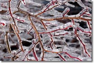
Freezing rain is a condition where precipitation which has fallen in the form of
water droplets reaches temperatures which are below freezing and freezes upon
coming into contact
with surface objects. The result of this precipitation is a glaze of ice which
can be damaging to plants and man-made structures. A severe onset of freezing
rain which results in a very thick glaze of ice is known as an ice storm.
Next Topic: Graupel
Weather Topic: What is Hail?
Home - Education - Precipitation - Hail
 Next Topic: Hole Punch Clouds
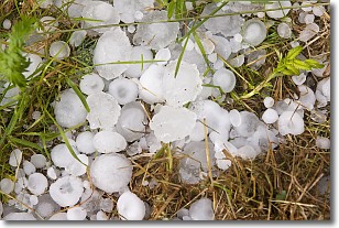
Hail is a form of precipitation which is recognized by large solid balls or
clumps of ice. Hail is created by thunderstorm clouds with strong updrafts of wind.
As the hailstones remain in the updraft, ice is deposited onto them until their
weight becomes heavy enough for them to fall to the earth's surface.
Hail storms can cause significant damage to crops, aircrafts, and man-made structures,
despite the fact that the duration is usually less than ten minutes.
Next Topic: Hole Punch Clouds
Current conditions powered by WeatherAPI.com


