Weather Alert in New York
Special Weather Statement issued February 25 at 4:32AM EST by NWS Burlington VT
AREAS AFFECTED: Northern St. Lawrence; Northern Franklin; Eastern Clinton; Southeastern St. Lawrence; Southern Franklin; Western Clinton; Western Essex; Eastern Essex; Southwestern St. Lawrence; Grand Isle; Western Franklin; Orleans; Essex; Western Chittenden; Lamoille; Caledonia; Washington; Western Addison; Orange; Western Rutland; Eastern Franklin; Eastern Chittenden; Eastern Addison; Eastern Rutland; Western Windsor; Eastern Windsor
DESCRIPTION: Snow is expected this morning, pushing eastward across northern New York and Vermont through 9 AM. Visibilities may drop as low as a half mile and roadways will become quickly snow covered, with accumulations between a half inch and two inches in most areas. After a break in the snow, scattered snow showers will develop this afternoon ahead of a cold front. If these showers develop, snow squalls will be possible into the evening hours. Affected locations will see rapidly changing weather and road conditions, with brief heavy snow and gusty winds.
INSTRUCTION: Motorists are urged to use extra caution while traveling this morning. If you are traveling and encounter adverse winter driving conditions, reduce speed and make sure headlights are on. Conditions can deteriorate rapidly in winter weather situations. Be prepared for snow or ice covered roads. Slow down and allow extra time when traveling.
Want more detail? Get the Complete 7 Day and Night Detailed Forecast!
Current U.S. National Radar--Current
The Current National Weather Radar is shown below with a UTC Time (subtract 5 hours from UTC to get Eastern Time).

National Weather Forecast--Current
The Current National Weather Forecast and National Weather Map are shown below.

National Weather Forecast for Tomorrow
Tomorrow National Weather Forecast and Tomorrow National Weather Map are show below.

North America Water Vapor (Moisture)
This map shows recent moisture content over North America. Bright and colored areas show high moisture (ie, clouds); brown indicates very little moisture present; black indicates no moisture.

Weather Topic: What are Cirrus Clouds?
Home - Education - Cloud Types - Cirrus Clouds
 Next Topic: Condensation
Cirrus clouds are high-level clouds that occur above 20,000 feet
and are composed mainly of ice crystals.
They are thin and wispy in appearance.
What do they indicate?
They are often the first sign of an approaching storm.
Next Topic: Condensation
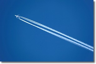
Weather Topic: What are Contrails?
Home - Education - Cloud Types - Contrails
 Next Topic: Cumulonimbus Clouds
A contrail is an artificial cloud, created by the passing of an
aircraft.
Contrails form because water vapor in the exhaust of aircraft engines is suspended
in the air under certain temperatures and humidity conditions. These contrails
are called exhaust contrails.
Another type of contrail can form due to a temporary reduction in air pressure
moving over the plane's surface, causing condensation.
These are called aerodynamic contrails.
When you can see your breath on a cold day, it is also because of condensation.
The reason contrails last longer than the condensation from your breath is
because the water in contrails freezes into ice particles.
Next Topic: Cumulonimbus Clouds
Current conditions powered by WeatherAPI.com


