Weather Alert in Idaho
Avalanche Warning issued February 25 at 2:45AM MST by NWS Boise ID
AREAS AFFECTED: Adams, ID; Gem, ID; Valley, ID
DESCRIPTION: The following message is transmitted at the request of the Payette National Forest Avalanche Center. ...The Payette National Forest Avalanche Center in McCall Idaho has issued a BACKCOUNTRY AVALANCHE WARNING... * WHAT...The avalanche danger for the West Central Mountains of Idaho will rise to HIGH on Tuesday afternoon and into Wednesday morning. Rain on snow and heavy, wet snow will create very dangerous avalanche conditions. * WHERE...The West Central Mountains of Idaho, including mountains near the communities of McCall, New Meadows, Donnelly, Cascade, and Yellow Pine. * WHEN...In effect from Tue 11:25 MST to Wed 11:45 MST. * IMPACTS...A warm, wet storm is bringing wet, heavy snowfall and rising rain levels up to 7000'. Natural and human-triggered avalanches large enough to bury people are very likely to occur. Even smaller steep slopes, like roadcuts, may also avalanche, depositing a surprising amount of debris on the road below.
INSTRUCTION: Travel on or underneath slopes steeper than 30 degrees is not recommended. Avalanches may run onto groomed snowmobile trails. Pay attention to the terrain above you as conditions change and as more snow and rain fall by the afternoon. Avalanches may impact roadways along the South Fork of the Salmon, Warm Lake Summit, and East Fork South Fork. Consult WWW.PAYETTEAVALANCHE.ORG or WWW.AVALANCHE.ORG for more detailed information. Similar avalanche danger may exist at locations outside the coverage area of this or any avalanche center. LAT...LON 4539 11600 4520 11584 4513 11579 4455 11577 4455 11603 4439 11600 4427 11613 4440 11627 4479 11635 4497 11622 4527 11633 4535 11635 4539 11629
Want more detail? Get the Complete 7 Day and Night Detailed Forecast!
Current U.S. National Radar--Current
The Current National Weather Radar is shown below with a UTC Time (subtract 5 hours from UTC to get Eastern Time).

National Weather Forecast--Current
The Current National Weather Forecast and National Weather Map are shown below.

National Weather Forecast for Tomorrow
Tomorrow National Weather Forecast and Tomorrow National Weather Map are show below.

North America Water Vapor (Moisture)
This map shows recent moisture content over North America. Bright and colored areas show high moisture (ie, clouds); brown indicates very little moisture present; black indicates no moisture.

Weather Topic: What is Freezing Rain?
Home - Education - Precipitation - Freezing Rain
 Next Topic: Graupel
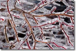
Freezing rain is a condition where precipitation which has fallen in the form of
water droplets reaches temperatures which are below freezing and freezes upon
coming into contact
with surface objects. The result of this precipitation is a glaze of ice which
can be damaging to plants and man-made structures. A severe onset of freezing
rain which results in a very thick glaze of ice is known as an ice storm.
Next Topic: Graupel
Weather Topic: What is Hail?
Home - Education - Precipitation - Hail
 Next Topic: Hole Punch Clouds
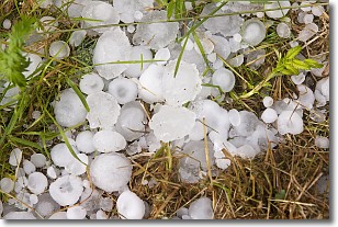
Hail is a form of precipitation which is recognized by large solid balls or
clumps of ice. Hail is created by thunderstorm clouds with strong updrafts of wind.
As the hailstones remain in the updraft, ice is deposited onto them until their
weight becomes heavy enough for them to fall to the earth's surface.
Hail storms can cause significant damage to crops, aircrafts, and man-made structures,
despite the fact that the duration is usually less than ten minutes.
Next Topic: Hole Punch Clouds
Current conditions powered by WeatherAPI.com


