Weather Alert in Idaho
Heat Advisory issued July 13 at 3:38AM PDT until July 14 at 8:00PM PDT by NWS Spokane WA
AREAS AFFECTED: Coeur d'Alene Area; Lewiston Area; Lower Garfield and Asotin Counties; Moses Lake Area; Upper Columbia Basin; Spokane Area; Wenatchee Area; Waterville Plateau
DESCRIPTION: * WHAT...High temperatures 95-105 on Sunday and 90-100 on Monday. Overnight low temperatures 65-75. * WHERE...Ephrata, Wilbur, Coeur d'Alene, Worley, Quincy, Hayden, Chelan, Spokane Valley, Number 1 Canyon, Moses Lake, Clarkston, Downtown Spokane, Davenport, Culdesac, Number 2 Canyon, Grand Coulee, Fairfield, Pomeroy, Ritzville, Badger Mountain Road, Lewiston Grade, Peck, Pangborn Airport, Lapwai, Cheney, Lewiston, Airway Heights, Wenatchee, Coulee City, Mansfield, Othello, Waterville, Gifford, Rockford, Alpowa Summit, Odessa, Entiat, Cashmere, Creston, Post Falls, and Harrington. * WHEN...Until 8 PM PDT Monday. * IMPACTS...Hot temperatures may cause heat illnesses. Warm low temperatures will limit ability to cool indoor spaces overnight for those without air conditioning.
INSTRUCTION: Drink plenty of fluids and check up on relatives and neighbors. Take extra precautions when outside. Wear lightweight and loose fitting clothing. Try to limit strenuous activities to early morning or evening. Take action when you see symptoms of heat exhaustion and heat stroke. If you have access to air conditioning, use it, or find a location that does. Even a few hours in a cool location can lower risk. Fans may not be adequate.
Want more detail? Get the Complete 7 Day and Night Detailed Forecast!
Current U.S. National Radar--Current
The Current National Weather Radar is shown below with a UTC Time (subtract 5 hours from UTC to get Eastern Time).

National Weather Forecast--Current
The Current National Weather Forecast and National Weather Map are shown below.

National Weather Forecast for Tomorrow
Tomorrow National Weather Forecast and Tomorrow National Weather Map are show below.

North America Water Vapor (Moisture)
This map shows recent moisture content over North America. Bright and colored areas show high moisture (ie, clouds); brown indicates very little moisture present; black indicates no moisture.

Weather Topic: What are Cirrus Clouds?
Home - Education - Cloud Types - Cirrus Clouds
 Next Topic: Condensation
Cirrus clouds are high-level clouds that occur above 20,000 feet
and are composed mainly of ice crystals.
They are thin and wispy in appearance.
What do they indicate?
They are often the first sign of an approaching storm.
Next Topic: Condensation
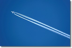
Weather Topic: What are Contrails?
Home - Education - Cloud Types - Contrails
 Next Topic: Cumulonimbus Clouds
A contrail is an artificial cloud, created by the passing of an
aircraft.
Contrails form because water vapor in the exhaust of aircraft engines is suspended
in the air under certain temperatures and humidity conditions. These contrails
are called exhaust contrails.
Another type of contrail can form due to a temporary reduction in air pressure
moving over the plane's surface, causing condensation.
These are called aerodynamic contrails.
When you can see your breath on a cold day, it is also because of condensation.
The reason contrails last longer than the condensation from your breath is
because the water in contrails freezes into ice particles.
Next Topic: Cumulonimbus Clouds
Current conditions powered by WeatherAPI.com


