Weather Alert in South Carolina
Flood Warning issued August 14 at 11:12AM EDT until August 18 at 10:24PM EDT by NWS Columbia SC
AREAS AFFECTED: Calhoun, SC; Richland, SC
DESCRIPTION: ...The Flood Warning is extended for the following rivers in South Carolina... Congaree River At Congaree River at Congaree NP Near Gadsden affecting Calhoun and Richland Counties. Congaree River At Carolina Eastman affecting Calhoun, Lexington and Richland Counties. * WHAT...Minor flooding is occurring and minor flooding is forecast. * WHERE...Congaree River at Congaree River at Congaree NP Near Gadsden. * WHEN...Until late Monday evening. * IMPACTS...At 15.0 feet, Flooding begins in the Congaree National Park. This will begin to produce flooding of portions of the lower boardwalk. At 17.0 feet, The access road to the Sandy Run subdivision becomes flooded. The lower boardwalk in the Congaree National Park becomes flooded by Cedar Creek. At 18.0 feet, Several homes in the Sandy Run subdivision along the river become flooded. At 18 feet the river covers the Weston Lake overlook in the Congaree National Park. Between 18 and 18.5 feet the river begins to cover sections of the elevated boardwalk. * ADDITIONAL DETAILS... - At 10:00 AM EDT Thursday the stage was 17.2 feet. - Bankfull stage is 14.0 feet. - Recent Activity...The maximum river stage in the 24 hours ending at 10:00 AM EDT Thursday was 17.2 feet. - Forecast...The river is expected to fall below flood stage late Sunday evening and continue falling to 12.2 feet Tuesday morning. - Flood stage is 15.0 feet. - http://www.weather.gov/safety/flood
INSTRUCTION: Residents and those with interests near the river should monitor rising water levels and take action if necessary. Caution is urged when walking near riverbanks. Additional information is available at www.weather.gov. The next statement will be issued this evening at 1100 PM EDT.
Want more detail? Get the Complete 7 Day and Night Detailed Forecast!
Current U.S. National Radar--Current
The Current National Weather Radar is shown below with a UTC Time (subtract 5 hours from UTC to get Eastern Time).

National Weather Forecast--Current
The Current National Weather Forecast and National Weather Map are shown below.

National Weather Forecast for Tomorrow
Tomorrow National Weather Forecast and Tomorrow National Weather Map are show below.

North America Water Vapor (Moisture)
This map shows recent moisture content over North America. Bright and colored areas show high moisture (ie, clouds); brown indicates very little moisture present; black indicates no moisture.

Weather Topic: What is Hail?
Home - Education - Precipitation - Hail
 Next Topic: Hole Punch Clouds
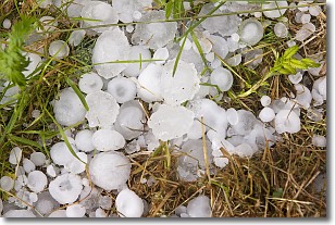
Hail is a form of precipitation which is recognized by large solid balls or
clumps of ice. Hail is created by thunderstorm clouds with strong updrafts of wind.
As the hailstones remain in the updraft, ice is deposited onto them until their
weight becomes heavy enough for them to fall to the earth's surface.
Hail storms can cause significant damage to crops, aircrafts, and man-made structures,
despite the fact that the duration is usually less than ten minutes.
Next Topic: Hole Punch Clouds
Weather Topic: What are Mammatus Clouds?
Home - Education - Cloud Types - Mammatus Clouds
 Next Topic: Nimbostratus Clouds
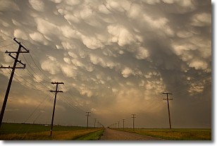
A mammatus cloud is a cloud with a unique feature which resembles
a web of pouches hanging along the base of the cloud.
In the United States, mammatus clouds tend to form in the warmer months, commonly
in the Midwest and eastern regions.
While they usually form at the bottom of a cumulonimbis cloud, they can also form
under altostratus, altocumulus, stratocumulus, and cirrus clouds. Mammatus clouds
warn that severe weather is close.
Next Topic: Nimbostratus Clouds
Current conditions powered by WeatherAPI.com


