Weather Alert in Montana
Hydrologic Outlook issued July 29 at 3:00PM MDT by NWS Great Falls MT
AREAS AFFECTED: Blaine, MT; Cascade, MT; Chouteau, MT; Fergus, MT; Glacier, MT; Hill, MT; Judith Basin, MT; Lewis and Clark, MT; Liberty, MT; Meagher, MT; Pondera, MT; Teton, MT; Toole, MT
DESCRIPTION: ESFTFX Soils across North-central and Central Montana are saturated due to well-above normal precipitation over the past month. Showers and thunderstorms will continue through at least Saturday over North- central and Central Montana. The Weather Prediction Center has a issued a Marginal Risk for excessive rainfall (5% chance for rainfall to exceed flash flood guidance within 25 miles of a point) Thursday through Saturday. Showers and thunderstorms today through saturday will be slow moving and produce rainfall rates capable of producing flash flooding. This will lead to the potential for flash flooding to occur with the greatest risk over urban areas, areas with poor drainage, and burn scars. Small creeks and streams have the potential for a quick but temporary rise downstream of any slow moving thunderstorm. Stay tuned to the forecast for any watches, advisories, or warnings. Please report any flooding to local law enforcement and have them relay the report to the National Weather Service.
INSTRUCTION: N/A
Want more detail? Get the Complete 7 Day and Night Detailed Forecast!
Current U.S. National Radar--Current
The Current National Weather Radar is shown below with a UTC Time (subtract 5 hours from UTC to get Eastern Time).

National Weather Forecast--Current
The Current National Weather Forecast and National Weather Map are shown below.

National Weather Forecast for Tomorrow
Tomorrow National Weather Forecast and Tomorrow National Weather Map are show below.

North America Water Vapor (Moisture)
This map shows recent moisture content over North America. Bright and colored areas show high moisture (ie, clouds); brown indicates very little moisture present; black indicates no moisture.

Weather Topic: What is Sleet?
Home - Education - Precipitation - Sleet
 Next Topic: Snow
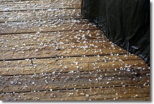
Sleet is a form of precipitation in which small ice pellets are the primary
components. These ice pellets are smaller and more translucent than hailstones,
and harder than graupel. Sleet is caused by specific atmospheric conditions and
therefore typically doesn't last for extended periods of time.
The condition which leads to sleet formation requires a warmer body of air to be
wedged in between two sub-freezing bodies of air. When snow falls through a warmer
layer of air it melts, and as it falls through the next sub-freezing body of air
it freezes again, forming ice pellets known as sleet. In some cases, water
droplets don't have time to freeze before reaching the surface and the result is
freezing rain.
Next Topic: Snow
Weather Topic: What are Stratocumulus Clouds?
Home - Education - Cloud Types - Stratocumulus Clouds
 Next Topic: Stratus Clouds
Stratocumulus clouds are similar to altocumulus clouds in their
fluffy appearance, but have a slightly darker shade due to their additional mass.
A good way to distinguish the two cloud types is to hold your hand out and measure
the size of an individual cloud; if it is the size of your thumb it is generally
an altocumulus cloud, if it is the size of your hand it is generally a
stratocumulus cloud.
It is uncommon for stratocumulus clouds to produce precipitation, but if they do
it is usually a light rain or snow.
Next Topic: Stratus Clouds
Current conditions powered by WeatherAPI.com


