Weather Alert in California
Heat Advisory issued August 10 at 10:26AM PDT until August 13 at 9:00AM PDT by NWS Reno NV
AREAS AFFECTED: Surprise Valley California; Lassen-Eastern Plumas-Eastern Sierra Counties; Mineral and Southern Lyon Counties; Greater Reno-Carson City-Minden Area; Western Nevada Basin and Range including Pyramid Lake; Northern Washoe County
DESCRIPTION: * WHAT...High temperatures ranging from 95-105 degrees in valleys and basins, with warmest lows between 65-72 degrees. Widespread Moderate to locally Major HeatRisk. * WHERE...In California, Lassen-Eastern Plumas-Eastern Sierra Counties and Surprise Valley California. In Nevada, Northern Washoe County, Western Nevada Basin and Range including Pyramid Lake, Greater Reno-Carson City-Minden Area, and Mineral and Southern Lyon Counties. * WHEN...From 11 AM Monday to 9 AM PDT Wednesday. * IMPACTS...Heat-related illnesses will be more likely, especially for those spending extended periods outdoors, in poorly cooled indoor spaces, or who are sensitive to heat. * ADDITIONAL DETAILS...Hottest conditions are expected Tuesday afternoon in lower valleys and basins. Cooler conditions above 4500 ft in Lassen-Eastern Plumas-Eastern Sierra counties and along foothill slopes outside the lower valleys.
INSTRUCTION: Drink plenty of fluids, stay in an air-conditioned location, avoid prolonged sun exposure, and check on relatives, neighbors, and pets. Limit strenuous activities to early morning or evening hours.
Want more detail? Get the Complete 7 Day and Night Detailed Forecast!
Current U.S. National Radar--Current
The Current National Weather Radar is shown below with a UTC Time (subtract 5 hours from UTC to get Eastern Time).

National Weather Forecast--Current
The Current National Weather Forecast and National Weather Map are shown below.

National Weather Forecast for Tomorrow
Tomorrow National Weather Forecast and Tomorrow National Weather Map are show below.

North America Water Vapor (Moisture)
This map shows recent moisture content over North America. Bright and colored areas show high moisture (ie, clouds); brown indicates very little moisture present; black indicates no moisture.

Weather Topic: What is Condensation?
Home - Education - Precipitation - Condensation
 Next Topic: Contrails
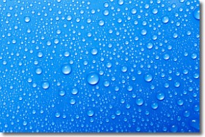
Condensation is the process which creates clouds, and therefore
it is a crucial process in the water cycle.
Condensation is the change of matter from a state of gas into a state of liquid,
and it happens because water molecules release heat into the atmosphere and
become organized into a more closely packed structure, what we might see as
water droplets.
Water is always present in the air around us as a vapor, but it's too small for
us to see. When water undergoes the process of condensation it becomes organized
into visible water droplets. You've probably seen condensation happen before on the
surface of a cold drink!
Next Topic: Contrails
Weather Topic: What are Cumulonimbus Clouds?
Home - Education - Cloud Types - Cumulonimbus Clouds
 Next Topic: Cumulus Clouds
The final form taken by a growing cumulus cloud is the
cumulonimbus cloud, which is very tall and dense.
The tower of a cumulonimbus cloud can soar 23 km into the atmosphere, although
most commonly they stop growing at an altitude of 6 km.
Even small cumulonimbus clouds appear very large in comparison to other cloud types.
They can signal the approach of stormy weather, such as thunderstorms or blizzards.
Next Topic: Cumulus Clouds
Current conditions powered by WeatherAPI.com


