Weather Alert in Illinois
Flood Watch issued August 14 at 4:42AM CDT until August 17 at 7:00AM CDT by NWS Milwaukee/Sullivan WI
AREAS AFFECTED: Lake, IL; Kenosha, WI
DESCRIPTION: ...The Flood Watch continues for the following rivers in Illinois... Wisconsin... Fox River Lower Near New Munster affecting Lake and Kenosha Counties. * WHAT...Flooding is possible. * WHERE...Fox River Lower near New Munster. * WHEN...From Saturday morning to Sunday morning. * IMPACTS...At 11.0 feet, Floodwaters begin to affect 77th St. in the Town of Wheatland. Floodwaters are near some homes along Riverside Dr, Shorewood Dr, and Highway W in the Village of Salem Lakes and Town of Wheatland areas. * ADDITIONAL DETAILS... - At 4:00 AM CDT Thursday the stage was 9.3 feet. - Forecast...Flood stage may be reached Saturday morning. - Flood stage is 11.0 feet. - http://www.weather.gov/safety/flood
INSTRUCTION: If you are in the watch area, remain alert to possible flooding. Additional information is available at www.weather.gov. The next statement will be issued this afternoon at 1245 PM CDT.
Want more detail? Get the Complete 7 Day and Night Detailed Forecast!
Current U.S. National Radar--Current
The Current National Weather Radar is shown below with a UTC Time (subtract 5 hours from UTC to get Eastern Time).

National Weather Forecast--Current
The Current National Weather Forecast and National Weather Map are shown below.

National Weather Forecast for Tomorrow
Tomorrow National Weather Forecast and Tomorrow National Weather Map are show below.

North America Water Vapor (Moisture)
This map shows recent moisture content over North America. Bright and colored areas show high moisture (ie, clouds); brown indicates very little moisture present; black indicates no moisture.

Weather Topic: What are Cirrostratus Clouds?
Home - Education - Cloud Types - Cirrostratus Clouds
 Next Topic: Cirrus Clouds
Cirrostratus clouds are high, thin clouds that form above
20,000 feet and are made mostly of ice crystals. They sometimes look like giant
feathers, horse tails, or curls of hair in the sky.
These clouds are pushed by the jet stream and can move at high speeds reaching
100 mph.
What do they indicate?
They indicate that a precipitation is likely within 24 hours.
Next Topic: Cirrus Clouds
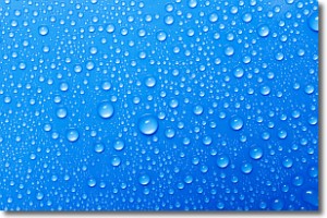
Weather Topic: What is Condensation?
Home - Education - Precipitation - Condensation
 Next Topic: Contrails
Condensation is the process which creates clouds, and therefore
it is a crucial process in the water cycle.
Condensation is the change of matter from a state of gas into a state of liquid,
and it happens because water molecules release heat into the atmosphere and
become organized into a more closely packed structure, what we might see as
water droplets.
Water is always present in the air around us as a vapor, but it's too small for
us to see. When water undergoes the process of condensation it becomes organized
into visible water droplets. You've probably seen condensation happen before on the
surface of a cold drink!
Next Topic: Contrails
Current conditions powered by WeatherAPI.com


