Weather Alert in North Carolina
Special Weather Statement issued August 12 at 2:21PM EDT by NWS Morristown TN
AREAS AFFECTED: Cherokee; Clay; Scott; Campbell; Claiborne; Hancock; Hawkins; Sullivan; Johnson; Morgan; Anderson; Union; Grainger; Hamblen; Northwest Cocke; Cocke Smoky Mountains; Northwest Greene; Southeast Greene; Washington; Unicoi; Northwest Carter; Southeast Carter; Roane; Loudon; Knox; Jefferson; NW Blount; Blount Smoky Mountains; North Sevier; Sevier Smoky Mountains; Sequatchie; Bledsoe; Rhea; Meigs; McMinn; Northwest Monroe; Southeast Monroe; Marion; Hamilton; Bradley; West Polk; East Polk; Lee; Wise; Scott; Russell; Washington
DESCRIPTION: A stream of tropical moisture will move north from the Gulf into the Tennessee valley and southern Appalachians through Wednesday. Periods of showers and embedded thunderstorms can be expected. Due to the abundant moisture these storms will be capable of producing excessive rainfall rates. If the storms move across the same locations, localized flash flooding is possible. Persons living near streams need stay alert for the potential of rapid water rise and flash flooding. Localized flooding of low lying areas and roadway flooding are possible. Please stay tuned to your NOAA weather radio and favorite radio and TV stations for the latest forecast and possible flash flood warnings or advisories in your area.
INSTRUCTION: N/A
Want more detail? Get the Complete 7 Day and Night Detailed Forecast!
Current U.S. National Radar--Current
The Current National Weather Radar is shown below with a UTC Time (subtract 5 hours from UTC to get Eastern Time).

National Weather Forecast--Current
The Current National Weather Forecast and National Weather Map are shown below.

National Weather Forecast for Tomorrow
Tomorrow National Weather Forecast and Tomorrow National Weather Map are show below.

North America Water Vapor (Moisture)
This map shows recent moisture content over North America. Bright and colored areas show high moisture (ie, clouds); brown indicates very little moisture present; black indicates no moisture.

Weather Topic: What is Hail?
Home - Education - Precipitation - Hail
 Next Topic: Hole Punch Clouds
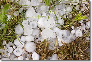
Hail is a form of precipitation which is recognized by large solid balls or
clumps of ice. Hail is created by thunderstorm clouds with strong updrafts of wind.
As the hailstones remain in the updraft, ice is deposited onto them until their
weight becomes heavy enough for them to fall to the earth's surface.
Hail storms can cause significant damage to crops, aircrafts, and man-made structures,
despite the fact that the duration is usually less than ten minutes.
Next Topic: Hole Punch Clouds
Weather Topic: What are Mammatus Clouds?
Home - Education - Cloud Types - Mammatus Clouds
 Next Topic: Nimbostratus Clouds
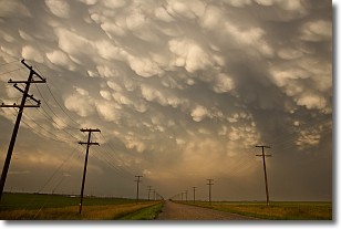
A mammatus cloud is a cloud with a unique feature which resembles
a web of pouches hanging along the base of the cloud.
In the United States, mammatus clouds tend to form in the warmer months, commonly
in the Midwest and eastern regions.
While they usually form at the bottom of a cumulonimbis cloud, they can also form
under altostratus, altocumulus, stratocumulus, and cirrus clouds. Mammatus clouds
warn that severe weather is close.
Next Topic: Nimbostratus Clouds
Current conditions powered by WeatherAPI.com


