Weather Alert in Colorado
Fire Weather Watch issued August 13 at 3:10AM MDT until August 14 at 10:00PM MDT by NWS Grand Junction CO
AREAS AFFECTED: Little Snake; White River; Lower Colorado River; Southwest Colorado Lower Forecast Area; Paradox Valley; Northern San Juan; North Fork; Gunnison Basin; Southwest Colorado Upper West Forecast Area; Southwest Colorado Upper East Forecast Area; Eastern Ashley National Forest; Eastern Uintah Basin; Book Cliffs; Colorado River Basin; Southeast Utah
DESCRIPTION: * AFFECTED AREA...In Colorado, Fire Weather Zone 200 Little Snake Forecast Area, Fire Weather Zone 202 White River Forecast Area, Fire Weather Zone 203 Lower Colorado River, Fire Weather Zone 207 Southwest Colorado Lower Forecast Area, Fire Weather Zone 290 Paradox Valley Forecast Area, Fire Weather Zone 291 Northern San Juan Forecast Area, Fire Weather Zone 292 North Fork Forecast Area, Fire Weather Zone 293 Gunnison Basin Forecast Area, Fire Weather Zone 294 Southwest Colorado Upper West Forecast Area and Fire Weather Zone 295 Southwest Colorado Upper East Forecast Area. In Utah, Fire Weather Zone 485 Eastern Ashley National Forest, Fire Weather Zone 486 Eastern Uinta Basin, Fire Weather Zone 487 Book Cliffs, Fire Weather Zone 490 Colorado River Basin and Fire Weather Zone 491 Southeast Utah. * TIMING...For the first Fire Weather Watch, from Thursday morning through Thursday evening. For the second Fire Weather Watch, from Friday morning through Friday evening. * IMPACTS...Any fire that develops will catch and spread quickly. Outdoor burning is not recommended. * THUNDERSTORMS...Scattered dry thunderstorms on Thursday and Friday will be capable of producing frequent lightning and gusty outflow winds which when combined with extremely dry conditions, will be capable of fire starts.
INSTRUCTION: A Fire Weather Watch means that critical fire weather conditions are forecast to occur. Listen for later forecasts and possible Red Flag Warnings.
Want more detail? Get the Complete 7 Day and Night Detailed Forecast!
Current U.S. National Radar--Current
The Current National Weather Radar is shown below with a UTC Time (subtract 5 hours from UTC to get Eastern Time).

National Weather Forecast--Current
The Current National Weather Forecast and National Weather Map are shown below.

National Weather Forecast for Tomorrow
Tomorrow National Weather Forecast and Tomorrow National Weather Map are show below.

North America Water Vapor (Moisture)
This map shows recent moisture content over North America. Bright and colored areas show high moisture (ie, clouds); brown indicates very little moisture present; black indicates no moisture.

Weather Topic: What is Fog?
Home - Education - Cloud Types - Fog
 Next Topic: Fractus Clouds
Fog is technically a type of stratus cloud, which lies along the
ground and obscures visibility.
It is usually created when humidity in the air condenses into tiny water droplets.
Because of this, some places are more prone to foggy weather, such as regions
close to a body of water.
Fog is similar to mist; both are the appearance of water droplets suspended in
the air, but fog is the term applied to the condition when visibility is less than 1 km.
Next Topic: Fractus Clouds
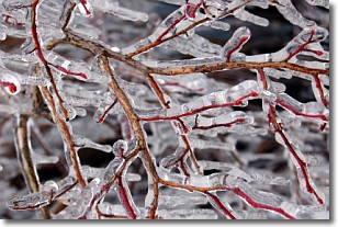
Weather Topic: What is Freezing Rain?
Home - Education - Precipitation - Freezing Rain
 Next Topic: Graupel
Freezing rain is a condition where precipitation which has fallen in the form of
water droplets reaches temperatures which are below freezing and freezes upon
coming into contact
with surface objects. The result of this precipitation is a glaze of ice which
can be damaging to plants and man-made structures. A severe onset of freezing
rain which results in a very thick glaze of ice is known as an ice storm.
Next Topic: Graupel
Current conditions powered by WeatherAPI.com


