Weather Alert in Idaho
Heat Advisory issued August 10 at 1:04PM PDT until August 12 at 8:00PM PDT by NWS Spokane WA
AREAS AFFECTED: Northern Panhandle; Coeur d'Alene Area; Idaho Palouse; Central Panhandle Mountains; Lewiston Area; Lower Garfield and Asotin Counties; Washington Palouse; Spokane Area; Northeast Mountains
DESCRIPTION: * WHAT...Hot temperatures. High temperatures 92 to 103 degrees. * WHERE...Oakesdale, Moscow, Uniontown, Chewelah, Pomeroy, Newport, Plummer, Airway Heights, Clark Fork, Genesee, Pinehurst, Lewiston Grade, Coeur d'Alene, La Crosse, Tekoa, Rockford, Northport, Fruitland, Sandpoint, Lookout Pass, Orin-Rice Road, Kellogg, Metaline Falls, Colfax, Priest River, Bonners Ferry, Dobson Pass, Clarkston, Pullman, Culdesac, Hayden, Athol, Springdale-Hunters Road, Mullan, Fourth Of July Pass, Worley, Potlatch, Cheney, Wallace, Fairfield, Lewiston, Flowery Trail Road, Peck, Schweitzer Mountain Road, Spokane Valley, Fernwood, Alpowa Summit, Osburn, Kettle Falls, Gifford, Lapwai, Deer Park, Rosalia, Eastport, Metaline, Davenport, Post Falls, Ione, St. Maries, Tiger, Colville, and Downtown Spokane. * WHEN...From noon Monday to 8 PM PDT Tuesday. * IMPACTS...Hot temperatures will increase the risk of heat-related illnesses, especially for those without effective cooling or adequate hydration.
INSTRUCTION: Drink plenty of fluids, stay in an air-conditioned room, stay out of the sun, and check up on relatives and neighbors.
Want more detail? Get the Complete 7 Day and Night Detailed Forecast!
Current U.S. National Radar--Current
The Current National Weather Radar is shown below with a UTC Time (subtract 5 hours from UTC to get Eastern Time).

National Weather Forecast--Current
The Current National Weather Forecast and National Weather Map are shown below.

National Weather Forecast for Tomorrow
Tomorrow National Weather Forecast and Tomorrow National Weather Map are show below.

North America Water Vapor (Moisture)
This map shows recent moisture content over North America. Bright and colored areas show high moisture (ie, clouds); brown indicates very little moisture present; black indicates no moisture.

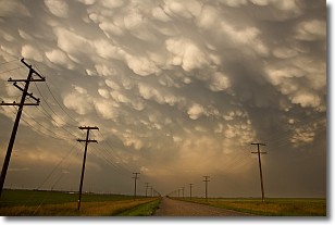
Weather Topic: What are Mammatus Clouds?
Home - Education - Cloud Types - Mammatus Clouds
 Next Topic: Nimbostratus Clouds
A mammatus cloud is a cloud with a unique feature which resembles
a web of pouches hanging along the base of the cloud.
In the United States, mammatus clouds tend to form in the warmer months, commonly
in the Midwest and eastern regions.
While they usually form at the bottom of a cumulonimbis cloud, they can also form
under altostratus, altocumulus, stratocumulus, and cirrus clouds. Mammatus clouds
warn that severe weather is close.
Next Topic: Nimbostratus Clouds
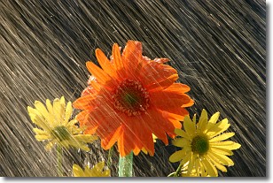
Weather Topic: What is Precipitation?
Home - Education - Precipitation - Precipitation
 Next Topic: Rain
Precipitation can refer to many different forms of water that
may fall from clouds. Precipitation occurs after a cloud has become saturated to
the point where its water particles are more dense than the air below the cloud.
In most cases, precipitation will reach the ground, but it is not uncommon for
precipitation to evaporate before it reaches the earth's surface.
When precipitation evaporates before it contacts the ground it is called Virga.
Graupel, hail, sleet, rain, drizzle, and snow are forms of precipitation, but fog
and mist are not considered precipitation because the water vapor which
constitutes them isn't dense enough to fall to the ground.
Next Topic: Rain
Current conditions powered by WeatherAPI.com


