Weather Alert in Illinois
Flood Warning issued April 3 at 12:14PM EDT by NWS Indianapolis IN
AREAS AFFECTED: Crawford, IL; Lawrence, IL; Knox, IN; Sullivan, IN
DESCRIPTION: ...The National Weather Service in Indianapolis IN has issued a Flood Warning for the following rivers in Indiana...Illinois... Wabash River at Riverton. .Multiple rounds of rainfall have brought lowland flooding to the Wabash River basin. The Wabash is expected to crest at Lafayette on Sunday, but the crest is not expected to reach the lower Wabash until the weekend of April 11th. The current river forecast includes expected rainfall amounts of 0.75 to 1.25 inches in the Wabash basin through Sunday morning, when dry weather is expected to move into the area. Variations from those expected amounts could change the crests as well as the amount of time spent in flood at any given location. * WHAT...Minor flooding is forecast. * WHERE...Wabash River at Riverton. * WHEN...From late tonight until further notice. * IMPACTS...At 18.5 feet, High water surrounds elevated river cabins. County roads to these cabins are impassable. Agricultural flooding is in progress. Seep water develops behind levees. * ADDITIONAL DETAILS... - At 11:00 AM EDT Friday /10:00 AM CDT Friday/ the stage was 11.7 feet. - Forecast...The river is expected to rise above flood stage late tonight and continue rising to a crest of 19.2 feet Friday, April 10. - Flood stage is 15.0 feet. - http://www.weather.gov/safety/flood
INSTRUCTION: Turn around, don't drown when encountering flooded roads. Most flood deaths occur in vehicles. Motorists should not attempt to drive around barricades or drive cars through flooded areas. Additional information is available at www.weather.gov/ind. The next statement should be issued this evening by around 1130 PM EDT /1030 PM CDT/.
Want more detail? Get the Complete 7 Day and Night Detailed Forecast!
Current U.S. National Radar--Current
The Current National Weather Radar is shown below with a UTC Time (subtract 5 hours from UTC to get Eastern Time).

National Weather Forecast--Current
The Current National Weather Forecast and National Weather Map are shown below.

National Weather Forecast for Tomorrow
Tomorrow National Weather Forecast and Tomorrow National Weather Map are show below.

North America Water Vapor (Moisture)
This map shows recent moisture content over North America. Bright and colored areas show high moisture (ie, clouds); brown indicates very little moisture present; black indicates no moisture.

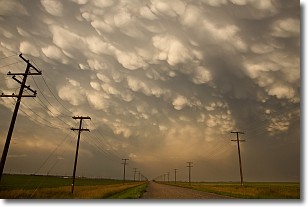
Weather Topic: What are Mammatus Clouds?
Home - Education - Cloud Types - Mammatus Clouds
 Next Topic: Nimbostratus Clouds
A mammatus cloud is a cloud with a unique feature which resembles
a web of pouches hanging along the base of the cloud.
In the United States, mammatus clouds tend to form in the warmer months, commonly
in the Midwest and eastern regions.
While they usually form at the bottom of a cumulonimbis cloud, they can also form
under altostratus, altocumulus, stratocumulus, and cirrus clouds. Mammatus clouds
warn that severe weather is close.
Next Topic: Nimbostratus Clouds
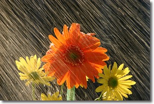
Weather Topic: What is Precipitation?
Home - Education - Precipitation - Precipitation
 Next Topic: Rain
Precipitation can refer to many different forms of water that
may fall from clouds. Precipitation occurs after a cloud has become saturated to
the point where its water particles are more dense than the air below the cloud.
In most cases, precipitation will reach the ground, but it is not uncommon for
precipitation to evaporate before it reaches the earth's surface.
When precipitation evaporates before it contacts the ground it is called Virga.
Graupel, hail, sleet, rain, drizzle, and snow are forms of precipitation, but fog
and mist are not considered precipitation because the water vapor which
constitutes them isn't dense enough to fall to the ground.
Next Topic: Rain
Current conditions powered by WeatherAPI.com


