Weather Alert in California
Flood Advisory issued February 24 at 7:21PM PST until February 24 at 9:30PM PST by NWS Eureka CA
AREAS AFFECTED: Humboldt, CA; Mendocino, CA; Trinity, CA
DESCRIPTION: * WHAT...Urban area and small stream flooding caused by excessive rainfall continues. * WHERE...Southeastern Humboldt County in northwestern California... Northeastern Mendocino County in northwestern California... Southwestern Trinity County in northwestern California... * WHEN...Until 930 PM PST. * IMPACTS...Minor flooding in low-lying and poor drainage areas. Overflowing at poor drainage areas and ponding of water in urban or other areas is occurring or is imminent. * ADDITIONAL DETAILS... - At 720 PM PST, Doppler radar and automated rain gauges indicated heavy rain. This is causing urban and small stream flooding. Overflowing poor drainage areas have already caused minor flooding in the advisory area. Between 3 and 6 inches of rain have fallen. - Additional rainfall amounts up to 0.1 inches are expected over the area. This additional rain will result in minor flooding. - Some locations that will experience flooding include... Willits, Garberville, Richardson Grove State Park, Covelo, Laytonville, Hayfork, Grizzly Creek Redwoods State Park, Alderpoint, Ruth, Forest Glen, Richardson Grove, Redway, Dinsmore, Leggett, Peanut, Myers Flat, Bridgeville and Hyampom. - http://www.weather.gov/safety/flood
INSTRUCTION: Turn around, don't drown when encountering flooded roads. Most flood deaths occur in vehicles. Be aware of your surroundings and do not drive on flooded roads. Please report observed flooding to local emergency services or law enforcement and request they pass this information to the National Weather Service when you can do so safely.
Want more detail? Get the Complete 7 Day and Night Detailed Forecast!
Current U.S. National Radar--Current
The Current National Weather Radar is shown below with a UTC Time (subtract 5 hours from UTC to get Eastern Time).

National Weather Forecast--Current
The Current National Weather Forecast and National Weather Map are shown below.

National Weather Forecast for Tomorrow
Tomorrow National Weather Forecast and Tomorrow National Weather Map are show below.

North America Water Vapor (Moisture)
This map shows recent moisture content over North America. Bright and colored areas show high moisture (ie, clouds); brown indicates very little moisture present; black indicates no moisture.

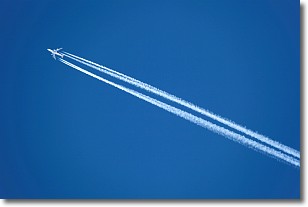
Weather Topic: What are Contrails?
Home - Education - Cloud Types - Contrails
 Next Topic: Cumulonimbus Clouds
A contrail is an artificial cloud, created by the passing of an
aircraft.
Contrails form because water vapor in the exhaust of aircraft engines is suspended
in the air under certain temperatures and humidity conditions. These contrails
are called exhaust contrails.
Another type of contrail can form due to a temporary reduction in air pressure
moving over the plane's surface, causing condensation.
These are called aerodynamic contrails.
When you can see your breath on a cold day, it is also because of condensation.
The reason contrails last longer than the condensation from your breath is
because the water in contrails freezes into ice particles.
Next Topic: Cumulonimbus Clouds
Weather Topic: What are Cumulus Clouds?
Home - Education - Cloud Types - Cumulus Clouds
 Next Topic: Drizzle
Cumulus clouds are fluffy and textured with rounded tops, and
may have flat bottoms. The border of a cumulus cloud
is clearly defined, and can have the appearance of cotton or cauliflower.
Cumulus clouds form at low altitudes (rarely above 2 km) but can grow very tall,
becoming cumulus congestus and possibly the even taller cumulonimbus clouds.
When cumulus clouds become taller, they have a greater chance of producing precipitation.
Next Topic: Drizzle
Current conditions powered by WeatherAPI.com


