Weather Alert in New Jersey
Flood Warning issued September 7 at 1:25AM EDT until September 7 at 4:00AM EDT by NWS Mount Holly NJ
AREAS AFFECTED: Mercer, NJ; Middlesex, NJ; Monmouth, NJ
DESCRIPTION: * WHAT...Flooding caused by excessive rainfall continues. * WHERE...Portions of central and northern New Jersey, including the following counties, in central New Jersey, Mercer and Monmouth. In northern New Jersey, Middlesex. * WHEN...Until 400 AM EDT. * IMPACTS...Flooding of rivers, creeks, streams, and other low-lying and flood-prone locations is imminent or occurring. * ADDITIONAL DETAILS... - At 124 AM EDT, Doppler radar indicated an area of heavy rainfall across the warned area. Between 1 and 2 inches of rain have fallen. - Additional rainfall amounts up to 0.5 inches are possible in the warned area. - Some locations that may experience flooding include... Old Bridge, East Brunswick, Marlboro, Manalapan, Jamesburg, Hightstown, Cranbury, Allentown, Roosevelt, Clearbrook Park, Twin Rivers and Whittingham. - http://www.weather.gov/safety/flood
INSTRUCTION: Turn around...don't drown when encountering flooded roads. Most flood deaths occur in vehicles. Be especially cautious at night when it is harder to recognize the dangers of flooding. Please report observed flooding to local emergency services or law enforcement and request they pass this information to the National Weather Service when you can do so safely.
Want more detail? Get the Complete 7 Day and Night Detailed Forecast!
Current U.S. National Radar--Current
The Current National Weather Radar is shown below with a UTC Time (subtract 5 hours from UTC to get Eastern Time).

National Weather Forecast--Current
The Current National Weather Forecast and National Weather Map are shown below.

National Weather Forecast for Tomorrow
Tomorrow National Weather Forecast and Tomorrow National Weather Map are show below.

North America Water Vapor (Moisture)
This map shows recent moisture content over North America. Bright and colored areas show high moisture (ie, clouds); brown indicates very little moisture present; black indicates no moisture.

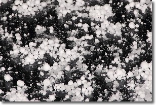
Weather Topic: What is Graupel?
Home - Education - Precipitation - Graupel
 Next Topic: Hail
Graupel is a form of precipitation that is created by atmospheric conditions
which cause supercooled water droplets to contact snow crystals and freeze to
their surface.
Sometimes known as soft hail or snow pellets, graupel is delicate and easily
destroyed by touch. Whereas hail usually falls during severe weather, graupel
doesn't require such conditions to form, and can form in mild precipitation
similar to situations which produce snowfall.
Next Topic: Hail
Weather Topic: What are Hole Punch Clouds?
Home - Education - Cloud Types - Hole Punch Clouds
 Next Topic: Mammatus Clouds
A hole punch cloud is an unusual occurrence when a disk-shaped
hole appears in a cirrostratus, cirrocumulus, or altocumulus cloud.
When part of the cloud forms ice crystals, water droplets in the surrounding area
of the cloud evaporate. The effect of this process produces a large elliptical
gap in the cloud. The hole punch cloud formation is rare, but it is not specific
to any geographic area.
Other names which have been used to describe this phenomena include fallstreak hole,
skypunch, and cloud hole.
Next Topic: Mammatus Clouds
Current conditions powered by WeatherAPI.com


