Weather Alert in Wisconsin
Flood Warning issued August 11 at 9:30PM CDT until August 14 at 9:00AM CDT by NWS Milwaukee/Sullivan WI
AREAS AFFECTED: Ozaukee, WI
DESCRIPTION: ...The Flood Warning is extended for the following rivers in Wisconsin... Cedar Creek At Cedarburg affecting Ozaukee County. Fox River Lower At Waukesha affecting Waukesha County. Milwaukee River Near Cedarburg affecting Ozaukee County. Root River At Franklin affecting Milwaukee County. ...The Flood Warning continues for the following rivers in Wisconsin... Menomonee River At Menomonee Falls affecting Waukesha County. * WHAT...Minor flooding is occurring and moderate flooding is forecast. * WHERE...Milwaukee River near Cedarburg. * WHEN...Until late Thursday morning. * IMPACTS...At 13.0 feet, Floodwaters affect Island Drive and Shoreland Parkway in the Mequon area. Water is over Elm St, Green Bay Rd, North Cedarburg Rd in Thiensville. The following roads and intersections are flooded and closed: Highway Y and Hawthorne Drive in the Town of Saukville, Highway W between Highway 33 and Highway 57 in the Village of Saukville. * ADDITIONAL DETAILS... - At 8:00 PM CDT Monday the stage was 12.9 feet. - Bankfull stage is 10.0 feet. - Recent Activity...The maximum river stage in the 24 hours ending at 8:00 PM CDT Monday was 12.9 feet. - Forecast...The river is expected to rise to a crest of 13.4 feet tomorrow morning. It will then fall below flood stage early Thursday morning. - Flood stage is 11.0 feet. - Flood History...This crest compares to a previous crest of 13.3 feet on 03/17/2019. - http://www.weather.gov/safety/flood
INSTRUCTION: Caution is urged when walking near riverbanks. Be especially cautious at night when it is harder to recognize the dangers of flooding. Motorists should not attempt to drive around barricades or drive cars through flooded areas. Turn around, don't drown when encountering flooded roads. Most flood deaths occur in vehicles. Additional information is available at www.weather.gov. The next statement will be issued Tuesday morning at 930 AM CDT.
Want more detail? Get the Complete 7 Day and Night Detailed Forecast!
Current U.S. National Radar--Current
The Current National Weather Radar is shown below with a UTC Time (subtract 5 hours from UTC to get Eastern Time).

National Weather Forecast--Current
The Current National Weather Forecast and National Weather Map are shown below.

National Weather Forecast for Tomorrow
Tomorrow National Weather Forecast and Tomorrow National Weather Map are show below.

North America Water Vapor (Moisture)
This map shows recent moisture content over North America. Bright and colored areas show high moisture (ie, clouds); brown indicates very little moisture present; black indicates no moisture.

Weather Topic: What is Fog?
Home - Education - Cloud Types - Fog
 Next Topic: Fractus Clouds
Fog is technically a type of stratus cloud, which lies along the
ground and obscures visibility.
It is usually created when humidity in the air condenses into tiny water droplets.
Because of this, some places are more prone to foggy weather, such as regions
close to a body of water.
Fog is similar to mist; both are the appearance of water droplets suspended in
the air, but fog is the term applied to the condition when visibility is less than 1 km.
Next Topic: Fractus Clouds
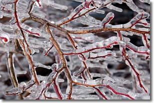
Weather Topic: What is Freezing Rain?
Home - Education - Precipitation - Freezing Rain
 Next Topic: Graupel
Freezing rain is a condition where precipitation which has fallen in the form of
water droplets reaches temperatures which are below freezing and freezes upon
coming into contact
with surface objects. The result of this precipitation is a glaze of ice which
can be damaging to plants and man-made structures. A severe onset of freezing
rain which results in a very thick glaze of ice is known as an ice storm.
Next Topic: Graupel
Current conditions powered by WeatherAPI.com


