Weather Alert in Indiana
Beach Hazards Statement issued August 20 at 11:16AM EDT until August 21 at 5:00AM EDT by NWS Northern Indiana
AREAS AFFECTED: Northern La Porte; Southern Berrien
DESCRIPTION: * WHAT...Dangerous swimming conditions expected. * Waves: Waves 3 to 5 feet this morning will temporarily subside to 2 to 4 feet this afternoon before returning to 3 to 5 feet this evening. Highest waves will be closest to New Buffalo, MI and Michigan City, IN. * Life-threatening rip and structural currents expected, especially on the north sides of piers and breakwalls. * A strong longshore current flowing from north to south is expected. * WHERE...In Indiana, Northern La Porte county. In Michigan, Southern Berrien county. * WHEN...Until late Wednesday night. * IMPACTS...Strong currents can pull swimmers into deeper water and high waves can sweep people off piers. ADDITIONAL INFORMATION...There may be a lull in wave heights to around 2 to 3 feet early this afternoon as winds diminish slightly. Winds and waves will begin to pick up later this afternoon and evening, with waves returning to around 4 to 5 feet.
INSTRUCTION: Remain out of the water to avoid hazardous swimming conditions. Do not venture out on piers.
Want more detail? Get the Complete 7 Day and Night Detailed Forecast!
Current U.S. National Radar--Current
The Current National Weather Radar is shown below with a UTC Time (subtract 5 hours from UTC to get Eastern Time).

National Weather Forecast--Current
The Current National Weather Forecast and National Weather Map are shown below.

National Weather Forecast for Tomorrow
Tomorrow National Weather Forecast and Tomorrow National Weather Map are show below.

North America Water Vapor (Moisture)
This map shows recent moisture content over North America. Bright and colored areas show high moisture (ie, clouds); brown indicates very little moisture present; black indicates no moisture.

Weather Topic: What are Fractus Clouds?
Home - Education - Cloud Types - Fractus Clouds
 Next Topic: Freezing Rain
A fractus cloud (scud) is a fragmented, tattered cloud which has
likely been sheared off of another cloud. They are accessory clouds, meaning they
develop from parent clouds, and are named in a way which describes the original
cloud which contained them.
Fractus clouds which have originated from cumulus clouds are referred to as
cumulus fractus, while fractus clouds which have originated from stratus clouds
are referred to as stratus fractus. Under certain conditions a fractus cloud might
merge with another cloud, or develop into a cumulus cloud, but usually a
fractus cloud seen by itself will dissipate rapidly.
They are often observed on the leading and trailing edges of storm clouds,
and are a display of wind activity.
Next Topic: Freezing Rain
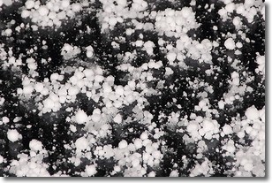
Weather Topic: What is Graupel?
Home - Education - Precipitation - Graupel
 Next Topic: Hail
Graupel is a form of precipitation that is created by atmospheric conditions
which cause supercooled water droplets to contact snow crystals and freeze to
their surface.
Sometimes known as soft hail or snow pellets, graupel is delicate and easily
destroyed by touch. Whereas hail usually falls during severe weather, graupel
doesn't require such conditions to form, and can form in mild precipitation
similar to situations which produce snowfall.
Next Topic: Hail
Current conditions powered by WeatherAPI.com


