Weather Alert in Iowa
Flood Warning issued August 2 at 3:06AM CDT until August 3 at 1:00AM CDT by NWS Des Moines IA
AREAS AFFECTED: Black Hawk, IA; Bremer, IA; Butler, IA
DESCRIPTION: ...The Flood Warning continues for the following rivers in Iowa... Iowa River near Tama Hwy E49 affecting Tama and Poweshiek Counties. Cedar River at Cedar Falls affecting Black Hawk County. Shell Rock River at Shell Rock affecting Bremer, Butler and Black Hawk Counties. * WHAT...Minor flooding is occurring and minor flooding is forecast. * WHERE...The Shell Rock River at Shell Rock, or from Flood Creek near Clarksville to the Cedar River. * WHEN...Until just after midnight tonight. * IMPACTS...At 12.5 feet, Seepage occurs in several basements close to the river. * ADDITIONAL DETAILS... - At 1:45 AM CDT Saturday the stage was 12.7 feet. - Forecast...The river is expected to fall below flood stage this evening and continue falling to 10.3 feet Friday evening. - Flood stage is 12.0 feet.
INSTRUCTION: For the latest waterway observations and forecasts refer to weather.gov/desmoines/water. Turn around, don't drown when encountering flooded roads. Most flood deaths occur in vehicles. River forecasts include observed precipitation plus forecast precipitation over the next 24 hours.
Want more detail? Get the Complete 7 Day and Night Detailed Forecast!
Current U.S. National Radar--Current
The Current National Weather Radar is shown below with a UTC Time (subtract 5 hours from UTC to get Eastern Time).

National Weather Forecast--Current
The Current National Weather Forecast and National Weather Map are shown below.

National Weather Forecast for Tomorrow
Tomorrow National Weather Forecast and Tomorrow National Weather Map are show below.

North America Water Vapor (Moisture)
This map shows recent moisture content over North America. Bright and colored areas show high moisture (ie, clouds); brown indicates very little moisture present; black indicates no moisture.

Weather Topic: What is Condensation?
Home - Education - Precipitation - Condensation
 Next Topic: Contrails
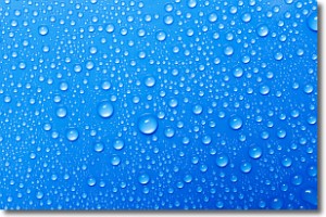
Condensation is the process which creates clouds, and therefore
it is a crucial process in the water cycle.
Condensation is the change of matter from a state of gas into a state of liquid,
and it happens because water molecules release heat into the atmosphere and
become organized into a more closely packed structure, what we might see as
water droplets.
Water is always present in the air around us as a vapor, but it's too small for
us to see. When water undergoes the process of condensation it becomes organized
into visible water droplets. You've probably seen condensation happen before on the
surface of a cold drink!
Next Topic: Contrails
Weather Topic: What are Cumulonimbus Clouds?
Home - Education - Cloud Types - Cumulonimbus Clouds
 Next Topic: Cumulus Clouds
The final form taken by a growing cumulus cloud is the
cumulonimbus cloud, which is very tall and dense.
The tower of a cumulonimbus cloud can soar 23 km into the atmosphere, although
most commonly they stop growing at an altitude of 6 km.
Even small cumulonimbus clouds appear very large in comparison to other cloud types.
They can signal the approach of stormy weather, such as thunderstorms or blizzards.
Next Topic: Cumulus Clouds
Current conditions powered by WeatherAPI.com


