Weather Alert in North Carolina
Flood Warning issued August 13 at 5:45AM EDT until August 15 at 11:00AM EDT by NWS Raleigh NC
AREAS AFFECTED: Johnston, NC
DESCRIPTION: ...The Flood Warning continues for the following rivers in North Carolina... Neuse River At Smithfield affecting Johnston County. * WHAT...Minor flooding is occurring and minor flooding is forecast. * WHERE...Neuse River at Smithfield. * WHEN...Until late Friday morning. * IMPACTS...At 15.0 feet, Minor flooding begins. Flooding begins along the Neuse Riverwalk. Water nears the base of the holding tank at the water treatment plant. At 18.0 feet, Moderate flooding begins. The Smithfield town park and the Neuse Riverwalk at the US70 bridge are flooded. * ADDITIONAL DETAILS... - At 5:15 AM EDT Wednesday the stage was 17.8 feet. - Forecast...The river is expected to rise to a crest of 17.9 feet this morning. It will then fall below flood stage late tomorrow evening. - Flood stage is 15.0 feet. - Flood History...This crest compares to a previous crest of 18.9 feet on 09/17/2018. - http://www.weather.gov/safety/flood
INSTRUCTION: Motorists should not attempt to drive around barricades or drive cars through flooded areas. Caution is urged when walking near riverbanks. Additional information is available at www.weather.gov/rah/rivers. The next statement will be issued this afternoon.
Want more detail? Get the Complete 7 Day and Night Detailed Forecast!
Current U.S. National Radar--Current
The Current National Weather Radar is shown below with a UTC Time (subtract 5 hours from UTC to get Eastern Time).

National Weather Forecast--Current
The Current National Weather Forecast and National Weather Map are shown below.

National Weather Forecast for Tomorrow
Tomorrow National Weather Forecast and Tomorrow National Weather Map are show below.

North America Water Vapor (Moisture)
This map shows recent moisture content over North America. Bright and colored areas show high moisture (ie, clouds); brown indicates very little moisture present; black indicates no moisture.

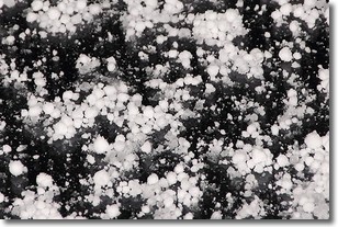
Weather Topic: What is Graupel?
Home - Education - Precipitation - Graupel
 Next Topic: Hail
Graupel is a form of precipitation that is created by atmospheric conditions
which cause supercooled water droplets to contact snow crystals and freeze to
their surface.
Sometimes known as soft hail or snow pellets, graupel is delicate and easily
destroyed by touch. Whereas hail usually falls during severe weather, graupel
doesn't require such conditions to form, and can form in mild precipitation
similar to situations which produce snowfall.
Next Topic: Hail
Weather Topic: What are Hole Punch Clouds?
Home - Education - Cloud Types - Hole Punch Clouds
 Next Topic: Mammatus Clouds
A hole punch cloud is an unusual occurrence when a disk-shaped
hole appears in a cirrostratus, cirrocumulus, or altocumulus cloud.
When part of the cloud forms ice crystals, water droplets in the surrounding area
of the cloud evaporate. The effect of this process produces a large elliptical
gap in the cloud. The hole punch cloud formation is rare, but it is not specific
to any geographic area.
Other names which have been used to describe this phenomena include fallstreak hole,
skypunch, and cloud hole.
Next Topic: Mammatus Clouds
Current conditions powered by WeatherAPI.com


