Weather Alert in California
Flood Advisory issued February 24 at 3:10PM PST until February 25 at 6:27PM PST by NWS Reno NV
AREAS AFFECTED: Lassen, CA
DESCRIPTION: ...The National Weather Service in Reno has issued a Flood Advisory for the following rivers in California... Susan River At Susanville affecting Lassen County. For the Susan River near Susanville. Minor flooding is forecast. * WHAT...Minor flooding caused by rain and snowmelt is expected. * WHERE...Susan River at Susanville. * WHEN...From this evening to tomorrow night. * IMPACTS...At 12.0 feet, Flood Stage. Local flooding in Susanville from Lassen Street downstream along Riverside Drive...especially below Paiute Creek which enters river near Alexander Drive. Moderate lowland flooding below Susanville in Johnstonville... Leavitt Lake...Standish... and Litchfield areas. Some rural roads affected by flooding. While the gage is expected to fall quickly below flood stage impacts downstream near Standish will be delayed and more prolonged. * ADDITIONAL DETAILS... - At 2:30 PM PST Tuesday the stage was 7.4 feet. - Forecast...The river will rise to flood stage late this evening near midnight tonight. It will below flood stage at the gage early Wednesday morning. - Action stage is 10.5 feet. - Flood stage is 12.0 feet. - http://www.weather.gov/safety/flood
INSTRUCTION: If you are in the advisory area, remain alert to possible flooding or the possibility of the advisory being upgraded to a warning. Be cautions of nighttime flooding. Please report observed flooding to local emergency services or law enforcement and request they pass this information to the National Weather Service when you can do so safely. Additional information is available at www.weather.gov. The next statement will be issued Wednesday evening at 630 PM PST.
Want more detail? Get the Complete 7 Day and Night Detailed Forecast!
Current U.S. National Radar--Current
The Current National Weather Radar is shown below with a UTC Time (subtract 5 hours from UTC to get Eastern Time).

National Weather Forecast--Current
The Current National Weather Forecast and National Weather Map are shown below.

National Weather Forecast for Tomorrow
Tomorrow National Weather Forecast and Tomorrow National Weather Map are show below.

North America Water Vapor (Moisture)
This map shows recent moisture content over North America. Bright and colored areas show high moisture (ie, clouds); brown indicates very little moisture present; black indicates no moisture.

Weather Topic: What is Fog?
Home - Education - Cloud Types - Fog
 Next Topic: Fractus Clouds
Fog is technically a type of stratus cloud, which lies along the
ground and obscures visibility.
It is usually created when humidity in the air condenses into tiny water droplets.
Because of this, some places are more prone to foggy weather, such as regions
close to a body of water.
Fog is similar to mist; both are the appearance of water droplets suspended in
the air, but fog is the term applied to the condition when visibility is less than 1 km.
Next Topic: Fractus Clouds
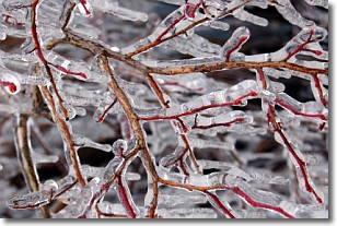
Weather Topic: What is Freezing Rain?
Home - Education - Precipitation - Freezing Rain
 Next Topic: Graupel
Freezing rain is a condition where precipitation which has fallen in the form of
water droplets reaches temperatures which are below freezing and freezes upon
coming into contact
with surface objects. The result of this precipitation is a glaze of ice which
can be damaging to plants and man-made structures. A severe onset of freezing
rain which results in a very thick glaze of ice is known as an ice storm.
Next Topic: Graupel
Current conditions powered by WeatherAPI.com


