Weather Alert in California
Heat Advisory issued August 11 at 11:59AM PDT until August 13 at 9:00AM PDT by NWS Reno NV
AREAS AFFECTED: Surprise Valley California; Lassen-Eastern Plumas-Eastern Sierra Counties; Mineral and Southern Lyon Counties; Greater Reno-Carson City-Minden Area; Western Nevada Basin and Range including Pyramid Lake; Northern Washoe County
DESCRIPTION: * WHAT...High temperatures ranging from 97-104 degrees in valleys and basins, with warmest lows between 65-70 degrees. Widespread Moderate to locally Major HeatRisk. * WHERE...In California, Lassen-Eastern Plumas-Eastern Sierra Counties and Surprise Valley California. In Nevada, Northern Washoe County, Western Nevada Basin and Range including Pyramid Lake, Greater Reno-Carson City-Minden Area, and Mineral and Southern Lyon Counties. * WHEN...Until 9 AM PDT Wednesday. * IMPACTS...Heat-related illnesses will be more likely, especially for those spending extended periods outdoors, in poorly cooled indoor spaces, or who are sensitive to heat. * ADDITIONAL DETAILS...Hottest conditions are expected Tuesday afternoon in lower valleys and basins. Cooler conditions above 4500 ft in Lassen-Eastern Plumas-Eastern Sierra counties and along foothill slopes outside the lower valleys.
INSTRUCTION: Drink plenty of fluids, stay in an air-conditioned location, avoid prolonged sun exposure, and check on relatives, neighbors, and pets. Limit strenuous activities to early morning or evening hours.
Want more detail? Get the Complete 7 Day and Night Detailed Forecast!
Current U.S. National Radar--Current
The Current National Weather Radar is shown below with a UTC Time (subtract 5 hours from UTC to get Eastern Time).

National Weather Forecast--Current
The Current National Weather Forecast and National Weather Map are shown below.

National Weather Forecast for Tomorrow
Tomorrow National Weather Forecast and Tomorrow National Weather Map are show below.

North America Water Vapor (Moisture)
This map shows recent moisture content over North America. Bright and colored areas show high moisture (ie, clouds); brown indicates very little moisture present; black indicates no moisture.

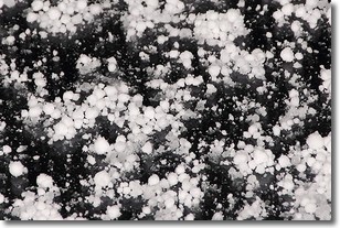
Weather Topic: What is Graupel?
Home - Education - Precipitation - Graupel
 Next Topic: Hail
Graupel is a form of precipitation that is created by atmospheric conditions
which cause supercooled water droplets to contact snow crystals and freeze to
their surface.
Sometimes known as soft hail or snow pellets, graupel is delicate and easily
destroyed by touch. Whereas hail usually falls during severe weather, graupel
doesn't require such conditions to form, and can form in mild precipitation
similar to situations which produce snowfall.
Next Topic: Hail
Weather Topic: What are Hole Punch Clouds?
Home - Education - Cloud Types - Hole Punch Clouds
 Next Topic: Mammatus Clouds
A hole punch cloud is an unusual occurrence when a disk-shaped
hole appears in a cirrostratus, cirrocumulus, or altocumulus cloud.
When part of the cloud forms ice crystals, water droplets in the surrounding area
of the cloud evaporate. The effect of this process produces a large elliptical
gap in the cloud. The hole punch cloud formation is rare, but it is not specific
to any geographic area.
Other names which have been used to describe this phenomena include fallstreak hole,
skypunch, and cloud hole.
Next Topic: Mammatus Clouds
Current conditions powered by WeatherAPI.com


