Weather Alert in Montana
Winter Storm Watch issued March 31 at 10:34AM MDT until April 3 at 6:00AM MDT by NWS Missoula MT
AREAS AFFECTED: Bitterroot/Sapphire Mountains; Butte/Blackfoot Region; Potomac/Seeley Lake Region
DESCRIPTION: * WHAT...Heavy snow possible. There is a chance of moderate to major winter weather impacts. Total snow accumulations between 6 and 12 inches possible for terrain above 5500 feet, including MacDonald Pass, Homestake Pass, Lost Trail Pass and Lolo Pass. 2 to 6 inches possible down to 3000 feet, including Butte, Seeley Lake and Anaconda. Winds could gust as high as 35 mph. * WHERE...Butte, Highway 12 Garrison to Elliston, I-90 East Missoula to Bearmouth, Georgetown Lake, Highway 93 Sula to Lost Trail Pass, Highway 83 Seeley Lake to Condon, Lolo Pass, MacDonald Pass, Homestake Pass, and Highway 200 Bonner to Greenough. * WHEN...From Thursday morning through late Thursday night. * IMPACTS...For MODERATE winter weather impacts, expect disruptions to normal activities. Hazardous traveling conditions. Use extra caution while driving. Closures and disruptions to infrastructure may occur. For MAJOR winter weather impacts, expect considerable disruptions to normal activities. Dangerous or impossible traveling conditions. Avoid travel in the impacted areas if possible. Widespread closures and disruptions to infrastructure may occur. The hazardous conditions could impact the Thursday morning and evening commutes, especially over higher passes. * ADDITIONAL DETAILS...Heavy, wet snow may cause power outages and tree damage.
INSTRUCTION: Monitor the latest forecasts for updates on this situation.
Want more detail? Get the Complete 7 Day and Night Detailed Forecast!
Current U.S. National Radar--Current
The Current National Weather Radar is shown below with a UTC Time (subtract 5 hours from UTC to get Eastern Time).

National Weather Forecast--Current
The Current National Weather Forecast and National Weather Map are shown below.

National Weather Forecast for Tomorrow
Tomorrow National Weather Forecast and Tomorrow National Weather Map are show below.

North America Water Vapor (Moisture)
This map shows recent moisture content over North America. Bright and colored areas show high moisture (ie, clouds); brown indicates very little moisture present; black indicates no moisture.

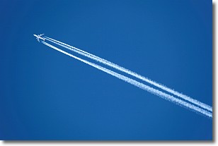
Weather Topic: What are Contrails?
Home - Education - Cloud Types - Contrails
 Next Topic: Cumulonimbus Clouds
A contrail is an artificial cloud, created by the passing of an
aircraft.
Contrails form because water vapor in the exhaust of aircraft engines is suspended
in the air under certain temperatures and humidity conditions. These contrails
are called exhaust contrails.
Another type of contrail can form due to a temporary reduction in air pressure
moving over the plane's surface, causing condensation.
These are called aerodynamic contrails.
When you can see your breath on a cold day, it is also because of condensation.
The reason contrails last longer than the condensation from your breath is
because the water in contrails freezes into ice particles.
Next Topic: Cumulonimbus Clouds
Weather Topic: What are Cumulus Clouds?
Home - Education - Cloud Types - Cumulus Clouds
 Next Topic: Drizzle
Cumulus clouds are fluffy and textured with rounded tops, and
may have flat bottoms. The border of a cumulus cloud
is clearly defined, and can have the appearance of cotton or cauliflower.
Cumulus clouds form at low altitudes (rarely above 2 km) but can grow very tall,
becoming cumulus congestus and possibly the even taller cumulonimbus clouds.
When cumulus clouds become taller, they have a greater chance of producing precipitation.
Next Topic: Drizzle
Current conditions powered by WeatherAPI.com


