Weather Alert in Wisconsin
Flood Warning issued August 14 at 4:42AM CDT until August 14 at 4:00PM CDT by NWS Milwaukee/Sullivan WI
AREAS AFFECTED: Ozaukee, WI
DESCRIPTION: ...The Flood Warning continues for the following rivers in Wisconsin... Cedar Creek At Cedarburg affecting Ozaukee County. Fox River Lower At Waukesha affecting Waukesha County. Milwaukee River Near Cedarburg affecting Ozaukee County. * WHAT...Minor flooding is forecast. * WHERE...Milwaukee River near Cedarburg. * WHEN...Until late this afternoon. * IMPACTS...At 11.0 feet, Water approaches some homes along Klug Lane just south of Highway C. At equivalent stage 2 1/2 miles downstream, water approaches homes along Island Drive and Shoreland Parkway in the Mequon area. * ADDITIONAL DETAILS... - At 4:00 AM CDT Thursday the stage was 11.0 feet. - Bankfull stage is 10.0 feet. - Forecast...The river is expected to rise to a crest of 11.1 feet this morning. It will then fall below flood stage late this morning. - Flood stage is 11.0 feet. - Flood History...This crest compares to a previous crest of 11.1 feet on 03/15/2007. - http://www.weather.gov/safety/flood
INSTRUCTION: Caution is urged when walking near riverbanks. Motorists should not attempt to drive around barricades or drive cars through flooded areas. Additional information is available at www.weather.gov. The next statement will be issued this afternoon at 400 PM CDT.
Want more detail? Get the Complete 7 Day and Night Detailed Forecast!
Current U.S. National Radar--Current
The Current National Weather Radar is shown below with a UTC Time (subtract 5 hours from UTC to get Eastern Time).

National Weather Forecast--Current
The Current National Weather Forecast and National Weather Map are shown below.

National Weather Forecast for Tomorrow
Tomorrow National Weather Forecast and Tomorrow National Weather Map are show below.

North America Water Vapor (Moisture)
This map shows recent moisture content over North America. Bright and colored areas show high moisture (ie, clouds); brown indicates very little moisture present; black indicates no moisture.

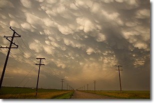
Weather Topic: What are Mammatus Clouds?
Home - Education - Cloud Types - Mammatus Clouds
 Next Topic: Nimbostratus Clouds
A mammatus cloud is a cloud with a unique feature which resembles
a web of pouches hanging along the base of the cloud.
In the United States, mammatus clouds tend to form in the warmer months, commonly
in the Midwest and eastern regions.
While they usually form at the bottom of a cumulonimbis cloud, they can also form
under altostratus, altocumulus, stratocumulus, and cirrus clouds. Mammatus clouds
warn that severe weather is close.
Next Topic: Nimbostratus Clouds
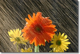
Weather Topic: What is Precipitation?
Home - Education - Precipitation - Precipitation
 Next Topic: Rain
Precipitation can refer to many different forms of water that
may fall from clouds. Precipitation occurs after a cloud has become saturated to
the point where its water particles are more dense than the air below the cloud.
In most cases, precipitation will reach the ground, but it is not uncommon for
precipitation to evaporate before it reaches the earth's surface.
When precipitation evaporates before it contacts the ground it is called Virga.
Graupel, hail, sleet, rain, drizzle, and snow are forms of precipitation, but fog
and mist are not considered precipitation because the water vapor which
constitutes them isn't dense enough to fall to the ground.
Next Topic: Rain
Current conditions powered by WeatherAPI.com


