Weather Alert in Kentucky
Severe Thunderstorm Watch issued September 5 at 5:45PM EDT until September 6 at 1:00AM EDT by NWS Jackson KY
AREAS AFFECTED: Bell, KY; Breathitt, KY; Clay, KY; Elliott, KY; Estill, KY; Floyd, KY; Harlan, KY; Jackson, KY; Johnson, KY; Knott, KY; Knox, KY; Laurel, KY; Lee, KY; Leslie, KY; Letcher, KY; McCreary, KY; Magoffin, KY; Martin, KY; Menifee, KY; Morgan, KY; Owsley, KY; Perry, KY; Pike, KY; Powell, KY; Pulaski, KY; Rockcastle, KY; Wayne, KY; Whitley, KY; Wolfe, KY
DESCRIPTION: THE NATIONAL WEATHER SERVICE HAS ISSUED SEVERE THUNDERSTORM WATCH 606 IN EFFECT UNTIL 1 AM EDT SATURDAY FOR THE FOLLOWING AREAS IN KENTUCKY THIS WATCH INCLUDES 29 COUNTIES IN EAST CENTRAL KENTUCKY ELLIOTT ESTILL MENIFEE POWELL IN NORTHEAST KENTUCKY JOHNSON MARTIN IN SOUTH CENTRAL KENTUCKY LAUREL MCCREARY PULASKI ROCKCASTLE WAYNE WHITLEY IN SOUTHEAST KENTUCKY BELL BREATHITT CLAY FLOYD HARLAN JACKSON KNOTT KNOX LEE LESLIE LETCHER MAGOFFIN MORGAN OWSLEY PERRY PIKE WOLFE THIS INCLUDES THE CITIES OF ANNVILLE, BARBOURVILLE, BEATTYVILLE, BOONEVILLE, BRODHEAD, BURNSIDE, CAMPTON, CLAY CITY, COAL RUN, CORBIN, CUMBERLAND, ELKHORN CITY, FRENCHBURG, HARLAN, HAZARD, HINDMAN, HYDEN, INEZ, IRVINE, JACKSON, JENKINS, LONDON, MANCHESTER, MCKEE, MIDDLESBORO, MONTICELLO, MOUNT VERNON, PAINTSVILLE, PIKEVILLE, PINEVILLE, PIPPA PASSES, PRESTONSBURG, RAVENNA, SALYERSVILLE, SANDY HOOK, SOMERSET, SOUTH WILLIAMSON, STANTON, STEARNS, WEST LIBERTY, WHEELWRIGHT, WHITESBURG, WHITLEY CITY, AND WILLIAMSBURG.
INSTRUCTION: N/A
Want more detail? Get the Complete 7 Day and Night Detailed Forecast!
Current U.S. National Radar--Current
The Current National Weather Radar is shown below with a UTC Time (subtract 5 hours from UTC to get Eastern Time).

National Weather Forecast--Current
The Current National Weather Forecast and National Weather Map are shown below.

National Weather Forecast for Tomorrow
Tomorrow National Weather Forecast and Tomorrow National Weather Map are show below.

North America Water Vapor (Moisture)
This map shows recent moisture content over North America. Bright and colored areas show high moisture (ie, clouds); brown indicates very little moisture present; black indicates no moisture.

Weather Topic: What is Freezing Rain?
Home - Education - Precipitation - Freezing Rain
 Next Topic: Graupel
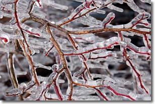
Freezing rain is a condition where precipitation which has fallen in the form of
water droplets reaches temperatures which are below freezing and freezes upon
coming into contact
with surface objects. The result of this precipitation is a glaze of ice which
can be damaging to plants and man-made structures. A severe onset of freezing
rain which results in a very thick glaze of ice is known as an ice storm.
Next Topic: Graupel
Weather Topic: What is Hail?
Home - Education - Precipitation - Hail
 Next Topic: Hole Punch Clouds
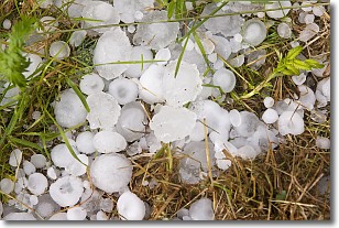
Hail is a form of precipitation which is recognized by large solid balls or
clumps of ice. Hail is created by thunderstorm clouds with strong updrafts of wind.
As the hailstones remain in the updraft, ice is deposited onto them until their
weight becomes heavy enough for them to fall to the earth's surface.
Hail storms can cause significant damage to crops, aircrafts, and man-made structures,
despite the fact that the duration is usually less than ten minutes.
Next Topic: Hole Punch Clouds
Current conditions powered by WeatherAPI.com


