Weather Alert in California
Flash Flood Warning issued June 3 at 10:20PM PDT until June 4 at 1:30AM PDT by NWS Las Vegas NV
AREAS AFFECTED: San Bernardino, CA
DESCRIPTION: FFWVEF The National Weather Service in Las Vegas has issued a * Flash Flood Warning for... San Bernardino County in southern California... * Until 130 AM PDT. * At 1020 PM PDT, Doppler radar indicated thunderstorms still producing heavy rain across southeast San Bernardino County. Flash flooding is likely ongoing, and could expand to include either Highway 95 or Highway 62 shortly. HAZARD...Life-threatening flash flooding. Thunderstorms producing flash flooding. SOURCE...Radar. IMPACT...Life-threatening flash flooding of low-water crossings, creeks, normally dry washes and roads. * Some locations that will experience flash flooding include... Havasu Landing, Mitchell Caverns, Highway 95 At Mile Marker 29, Parker Dam, Needles, Essex, Amboy, Highway 95 And I-40, Vidal Junction, Twentynine Palms Airport, Mohave Valley, Big River, Earp, Three Dunes Campground and Black Meadow Landing Campground.
INSTRUCTION: Turn around, don't drown when encountering flooded roads. Most flood deaths occur in vehicles.
Want more detail? Get the Complete 7 Day and Night Detailed Forecast!
Current U.S. National Radar--Current
The Current National Weather Radar is shown below with a UTC Time (subtract 5 hours from UTC to get Eastern Time).

National Weather Forecast--Current
The Current National Weather Forecast and National Weather Map are shown below.

National Weather Forecast for Tomorrow
Tomorrow National Weather Forecast and Tomorrow National Weather Map are show below.

North America Water Vapor (Moisture)
This map shows recent moisture content over North America. Bright and colored areas show high moisture (ie, clouds); brown indicates very little moisture present; black indicates no moisture.

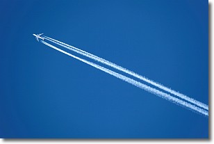
Weather Topic: What are Contrails?
Home - Education - Cloud Types - Contrails
 Next Topic: Cumulonimbus Clouds
A contrail is an artificial cloud, created by the passing of an
aircraft.
Contrails form because water vapor in the exhaust of aircraft engines is suspended
in the air under certain temperatures and humidity conditions. These contrails
are called exhaust contrails.
Another type of contrail can form due to a temporary reduction in air pressure
moving over the plane's surface, causing condensation.
These are called aerodynamic contrails.
When you can see your breath on a cold day, it is also because of condensation.
The reason contrails last longer than the condensation from your breath is
because the water in contrails freezes into ice particles.
Next Topic: Cumulonimbus Clouds
Weather Topic: What are Cumulus Clouds?
Home - Education - Cloud Types - Cumulus Clouds
 Next Topic: Drizzle
Cumulus clouds are fluffy and textured with rounded tops, and
may have flat bottoms. The border of a cumulus cloud
is clearly defined, and can have the appearance of cotton or cauliflower.
Cumulus clouds form at low altitudes (rarely above 2 km) but can grow very tall,
becoming cumulus congestus and possibly the even taller cumulonimbus clouds.
When cumulus clouds become taller, they have a greater chance of producing precipitation.
Next Topic: Drizzle
Current conditions powered by WeatherAPI.com


