Weather Alert in Washington
Red Flag Warning issued July 29 at 2:15PM PDT until July 30 at 9:00PM PDT by NWS Pendleton OR
AREAS AFFECTED: East Washington South Central Cascade Mountains
DESCRIPTION: ...RED FLAG WARNING IN EFFECT FROM 2 PM TO 11 PM PDT TUESDAY FOR ABUNDANT LIGHTNING FOR FIRE WEATHER ZONES OR697, OR698, OR699, OR700, AND OR705... ...RED FLAG WARNING IN EFFECT FROM 1 PM WEDNESDAY TO 11 AM THURSDAY FOR ABUNDANT LIGHTNING FOR FIRE WEATHER ZONES OR700, OR704, AND OR705... ...RED FLAG WARNING IN EFFECT FROM 1 PM TO 9 PM WEDNESDAY FOR ABUNDANT LIGHTNING FOR FIRE WEATHER ZONE WA695... .Multiple rounds of showers and thunderstorms are forecast through Friday. While some of these storms may produce wetting rains, their high-based nature will increase the probability of isolated (today) to scattered (Wednesday) dry thunderstorms. Showers and thunderstorms will be capable of producing gusty and erratic outflow winds up to 60 mph. The National Weather Service in Pendleton has issued a Red Flag Warning for abundant lightning, which is in effect from 1 PM to 9 PM PDT Wednesday. The Fire Weather Watch is no longer in effect. * AFFECTED AREA...Fire Weather Zone 695 East Washington South Central Cascade Mountains. * TIMING...From 1 PM to 9 PM PDT Wednesday. * IMPACTS...Any fire that develops will catch and spread quickly. Outdoor burning is not recommended. * THUNDERSTORMS...Abundant lightning and isolated dry thunderstorms. * OUTFLOW WINDS...Gusty, erratic winds with gusts up to 50 mph.
INSTRUCTION: A Red Flag Warning means that critical fire weather conditions are either occurring now, or will shortly. A combination of strong winds, low relative humidity, and warm temperatures can contribute to extreme fire behavior.
Want more detail? Get the Complete 7 Day and Night Detailed Forecast!
Current U.S. National Radar--Current
The Current National Weather Radar is shown below with a UTC Time (subtract 5 hours from UTC to get Eastern Time).

National Weather Forecast--Current
The Current National Weather Forecast and National Weather Map are shown below.

National Weather Forecast for Tomorrow
Tomorrow National Weather Forecast and Tomorrow National Weather Map are show below.

North America Water Vapor (Moisture)
This map shows recent moisture content over North America. Bright and colored areas show high moisture (ie, clouds); brown indicates very little moisture present; black indicates no moisture.

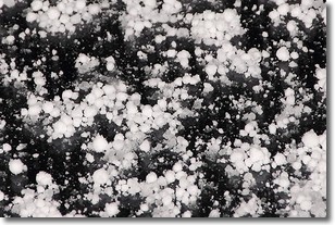
Weather Topic: What is Graupel?
Home - Education - Precipitation - Graupel
 Next Topic: Hail
Graupel is a form of precipitation that is created by atmospheric conditions
which cause supercooled water droplets to contact snow crystals and freeze to
their surface.
Sometimes known as soft hail or snow pellets, graupel is delicate and easily
destroyed by touch. Whereas hail usually falls during severe weather, graupel
doesn't require such conditions to form, and can form in mild precipitation
similar to situations which produce snowfall.
Next Topic: Hail
Weather Topic: What are Hole Punch Clouds?
Home - Education - Cloud Types - Hole Punch Clouds
 Next Topic: Mammatus Clouds
A hole punch cloud is an unusual occurrence when a disk-shaped
hole appears in a cirrostratus, cirrocumulus, or altocumulus cloud.
When part of the cloud forms ice crystals, water droplets in the surrounding area
of the cloud evaporate. The effect of this process produces a large elliptical
gap in the cloud. The hole punch cloud formation is rare, but it is not specific
to any geographic area.
Other names which have been used to describe this phenomena include fallstreak hole,
skypunch, and cloud hole.
Next Topic: Mammatus Clouds
Current conditions powered by WeatherAPI.com


