Weather Alert in New Jersey
High Surf Advisory issued August 20 at 6:26AM EDT until August 22 at 6:00PM EDT by NWS Mount Holly NJ
AREAS AFFECTED: Eastern Monmouth
DESCRIPTION: * WHAT...For the High Surf Advisory, large breaking waves of 5 to 8 feet expected in the surf zone on Wednesday and 7 to 12 feet on Thursday. For the High Rip Current Risk, life-threatening rip currents. For the Coastal Flood Watch, one to two feet of inundation above ground level possible in low- lying areas near shorelines and tidal waterways. * WHERE...Eastern Monmouth. * WHEN...For the High Surf Advisory, until 6 PM EDT Friday. For the High Rip Current Risk, through Friday afternoon. For the Coastal Flood Watch, from Thursday afternoon through late Friday night. * IMPACTS...At this level, widespread roadway flooding occurs in coastal and bayside communities and along inland tidal waterways. Many roads become impassable. Some damage to vulnerable structures may begin to occur. Dangerous swimming and surfing conditions and localized beach erosion. Rip currents can sweep even the best swimmers away from shore into deeper water.
INSTRUCTION: A Coastal Flood Watch means that conditions favorable for flooding are expected to develop. Be prepared to begin taking appropriate action to protect life and property. Follow the recommendations of local emergency management officials. Be sure to check the latest forecast from time to time in case a warning is issued or any new information becomes available. Visit the Advanced Hydrologic Prediction Service at water.weather.gov/ahps for additional water level and flood impact information for your local tide gauge. Inexperienced swimmers should remain out of the water due to dangerous surf conditions. Always obey posted Beach Flags. If you enter the surf zone, always have a floatation device with you and swim near a lifeguard if possible. If caught in a rip current, relax and float and do not swim against the current. If able, swim parallel to the shoreline. If unable to escape, face the shore and call or wave for help.
Want more detail? Get the Complete 7 Day and Night Detailed Forecast!
Current U.S. National Radar--Current
The Current National Weather Radar is shown below with a UTC Time (subtract 5 hours from UTC to get Eastern Time).

National Weather Forecast--Current
The Current National Weather Forecast and National Weather Map are shown below.

National Weather Forecast for Tomorrow
Tomorrow National Weather Forecast and Tomorrow National Weather Map are show below.

North America Water Vapor (Moisture)
This map shows recent moisture content over North America. Bright and colored areas show high moisture (ie, clouds); brown indicates very little moisture present; black indicates no moisture.

Weather Topic: What are Cumulus Clouds?
Home - Education - Cloud Types - Cumulus Clouds
 Next Topic: Drizzle
Cumulus clouds are fluffy and textured with rounded tops, and
may have flat bottoms. The border of a cumulus cloud
is clearly defined, and can have the appearance of cotton or cauliflower.
Cumulus clouds form at low altitudes (rarely above 2 km) but can grow very tall,
becoming cumulus congestus and possibly the even taller cumulonimbus clouds.
When cumulus clouds become taller, they have a greater chance of producing precipitation.
Next Topic: Drizzle
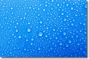
Weather Topic: What is Evaporation?
Home - Education - Precipitation - Evaporation
 Next Topic: Fog
Evaporation is the process which returns water from the earth
back to the atmosphere, and is another crucial process in the water cycle.
Evaporation is the transformation of liquid into gas, and it happens because
molecules are excited by the application of energy and turn into vapor.
In order for water to evaporate it has to be on the surface of a body of water.
Next Topic: Fog
Current conditions powered by WeatherAPI.com


