Weather Alert in Louisiana
Air Quality Alert issued September 12 at 12:09AM CDT by NWS New Orleans LA
AREAS AFFECTED: Pointe Coupee; Iberville; West Baton Rouge; East Baton Rouge; Northern Livingston; Southern Livingston; Western Ascension; Eastern Ascension
DESCRIPTION: The Louisiana Department of Environmental Quality is forecasting an Ozone Advisory Day for East Baton Rouge, West Baton Rouge, Livingston, Ascension, Iberville, and Pointe Coupee Parishes, . The Air Quality Index indicates that ozone will be at the Orange level, which is unhealthy for sensitive groups. Increasing ozone levels may cause unhealthy air quality during afternoon hours. Active children and adults, the elderly, and people with respiratory diseases such as asthma should avoid prolonged outdoor exertion. Please take whatever voluntary steps you can to reduce emissions that contribute to ozone formation. Drive less and make sure your automobile is in good working condition. Make sure your gas cap is tight. Wait until after 6 PM to refuel your vehicle and use gas powered lawn equipment. More information about current air quality and what you can do to help prevent ozone formation is available at the D E Q website www.deq.louisiana.gov/enviroflash or by calling 8 6 6 8 9 6 5 3 3 7.
INSTRUCTION: N/A
Want more detail? Get the Complete 7 Day and Night Detailed Forecast!
Current U.S. National Radar--Current
The Current National Weather Radar is shown below with a UTC Time (subtract 5 hours from UTC to get Eastern Time).

National Weather Forecast--Current
The Current National Weather Forecast and National Weather Map are shown below.

National Weather Forecast for Tomorrow
Tomorrow National Weather Forecast and Tomorrow National Weather Map are show below.

North America Water Vapor (Moisture)
This map shows recent moisture content over North America. Bright and colored areas show high moisture (ie, clouds); brown indicates very little moisture present; black indicates no moisture.

Weather Topic: What are Cumulus Clouds?
Home - Education - Cloud Types - Cumulus Clouds
 Next Topic: Drizzle
Cumulus clouds are fluffy and textured with rounded tops, and
may have flat bottoms. The border of a cumulus cloud
is clearly defined, and can have the appearance of cotton or cauliflower.
Cumulus clouds form at low altitudes (rarely above 2 km) but can grow very tall,
becoming cumulus congestus and possibly the even taller cumulonimbus clouds.
When cumulus clouds become taller, they have a greater chance of producing precipitation.
Next Topic: Drizzle
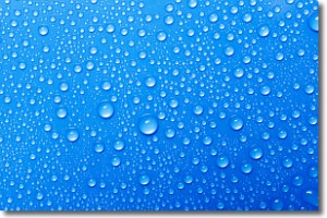
Weather Topic: What is Evaporation?
Home - Education - Precipitation - Evaporation
 Next Topic: Fog
Evaporation is the process which returns water from the earth
back to the atmosphere, and is another crucial process in the water cycle.
Evaporation is the transformation of liquid into gas, and it happens because
molecules are excited by the application of energy and turn into vapor.
In order for water to evaporate it has to be on the surface of a body of water.
Next Topic: Fog
Current conditions powered by WeatherAPI.com


