Weather Alert in Illinois
Severe Thunderstorm Warning issued April 2 at 4:51PM CDT until April 2 at 5:30PM CDT by NWS Quad Cities IA IL
AREAS AFFECTED: Henderson, IL; Henry, IL; Mercer, IL; Rock Island, IL; Warren, IL; Scott, IA
DESCRIPTION: At 451 PM CDT, severe thunderstorms were located along a line extending from Andalusia to Decorra, moving northeast at 50 mph. HAZARD...60 mph wind gusts and quarter size hail. SOURCE...Radar indicated. IMPACT...Hail damage to vehicles is expected. Expect wind damage to roofs, siding, and trees. Locations impacted include... Davenport, Rock Island, Aledo, Oquawka, Buffalo, Andalusia, Stronghurst, Millersburg, Reynolds, Biggsville, Milan, Oak Grove, Little York, Media, Rock Island Arsenal, Blackhawk State Park, Mississippi Valley Fairgrounds, Moline, Bettendorf, Eldridge, Matherville, Kirkwood, Shale City, Preemption, Wanlock, Coyne Center, Davenport Municipal Airport, Burgess, Viola, Riverdale, Boden, Eleanor, Moline Quad-City Airport, Fruitland, Gilchrist, Indian Bluff Golf Course, East Moline, Coal Valley, Sherrard, Lake Warren, Panorama Park, Silvis, Le Claire, Hampton, Princeton, Cable, Campbells Island, Silvis Heights, Illiniwek Forest Preserve, Pleasant Valley, Fishermans Corner, Port Byron, Rapids City, Cordova, Carbon Cliff, Alexis, Sunny Hill Estates, Princeton Wildlife Area, Griffin, Colona, Warner, Sunny Hill, Swedona and Barstow. This includes the following highways... Interstate 74 in Iowa between mile markers 1 and 5. Interstate 80 in Iowa between mile markers 291 and 306. Interstate 80 in Illinois between mile markers 1 and 13. Interstate 74 in Illinois between mile markers 1 and 27. Interstate 88 between mile markers 1 and 6. Interstate 280 between mile markers 1 and 18.
INSTRUCTION: A Tornado Watch remains in effect until 800 PM CDT for northwestern and west central Illinois...and southeastern and east central Iowa. Remain alert for a possible tornado! Tornadoes can develop quickly from severe thunderstorms. If you spot a tornado go at once into the basement or small central room in a sturdy structure. To report severe weather contact your nearest law enforcement agency. They will send your report to the National Weather Service office in the Quad Cities.
Want more detail? Get the Complete 7 Day and Night Detailed Forecast!
Current U.S. National Radar--Current
The Current National Weather Radar is shown below with a UTC Time (subtract 5 hours from UTC to get Eastern Time).

National Weather Forecast--Current
The Current National Weather Forecast and National Weather Map are shown below.

National Weather Forecast for Tomorrow
Tomorrow National Weather Forecast and Tomorrow National Weather Map are show below.

North America Water Vapor (Moisture)
This map shows recent moisture content over North America. Bright and colored areas show high moisture (ie, clouds); brown indicates very little moisture present; black indicates no moisture.

Weather Topic: What is Fog?
Home - Education - Cloud Types - Fog
 Next Topic: Fractus Clouds
Fog is technically a type of stratus cloud, which lies along the
ground and obscures visibility.
It is usually created when humidity in the air condenses into tiny water droplets.
Because of this, some places are more prone to foggy weather, such as regions
close to a body of water.
Fog is similar to mist; both are the appearance of water droplets suspended in
the air, but fog is the term applied to the condition when visibility is less than 1 km.
Next Topic: Fractus Clouds
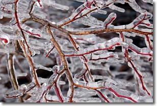
Weather Topic: What is Freezing Rain?
Home - Education - Precipitation - Freezing Rain
 Next Topic: Graupel
Freezing rain is a condition where precipitation which has fallen in the form of
water droplets reaches temperatures which are below freezing and freezes upon
coming into contact
with surface objects. The result of this precipitation is a glaze of ice which
can be damaging to plants and man-made structures. A severe onset of freezing
rain which results in a very thick glaze of ice is known as an ice storm.
Next Topic: Graupel
Current conditions powered by WeatherAPI.com


