Weather Alert in Michigan
Flood Watch issued April 4 at 10:28PM EDT until April 10 at 4:00PM EDT by NWS Grand Rapids MI
AREAS AFFECTED: Kent
DESCRIPTION: ...The National Weather Service in Grand Rapids MI has issued a Flood Watch for the following rivers in Michigan... Grand River at Lowell affecting Kent County. ...The Flood Watch is extended for the following rivers in Michigan... Grand River at Ada affecting Kent County. Grand River at Robinson Township affecting Ottawa County. Grand River at Grand Rapids affecting Kent County. ...The Flood Watch is replaced by a River Flood Warning for the following rivers in Michigan... Grand River at Ionia affecting Ionia County. .Rainfall of 1 to 3 inches has fallen in the past 24 hours on already saturated soil causing rivers to rise. Minor river flooding is possible. * WHAT...Flooding is possible. * WHERE...Grand River at Lowell. * WHEN...From Monday morning to Friday afternoon. * IMPACTS...At 16.0 feet, Lowell fairgrounds flooded, low sections of Bowes Road, Division, Front Street, and Jackson flooded in the city of Lowell. * ADDITIONAL DETAILS... - At 5:40 PM EDT Saturday the stage was 10.6 feet. - Forecast...Flood stage may be reached late Monday morning. - Flood stage is 15.0 feet. - http://www.weather.gov/safety/flood
INSTRUCTION: Residents and those with interests near the river should monitor rising water levels and be prepared for possible flood warnings. If you are in the watch area, remain alert to possible flooding. Additional information is available at www.weather.gov/grr.
Want more detail? Get the Complete 7 Day and Night Detailed Forecast!
Current U.S. National Radar--Current
The Current National Weather Radar is shown below with a UTC Time (subtract 5 hours from UTC to get Eastern Time).

National Weather Forecast--Current
The Current National Weather Forecast and National Weather Map are shown below.

National Weather Forecast for Tomorrow
Tomorrow National Weather Forecast and Tomorrow National Weather Map are show below.

North America Water Vapor (Moisture)
This map shows recent moisture content over North America. Bright and colored areas show high moisture (ie, clouds); brown indicates very little moisture present; black indicates no moisture.

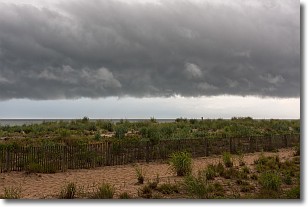
Weather Topic: What are Shelf Clouds?
Home - Education - Cloud Types - Shelf Clouds
 Next Topic: Sleet
A shelf cloud is similar to a wall cloud, but forms at the front
of a storm cloud, instead of at the rear, where wall clouds form.
A shelf cloud is caused by a series of events set into motion by the advancing
storm; first, cool air settles along the ground where precipitation has just fallen.
As the cool air is brought in, the warmer air is displaced, and rises above it,
because it is less dense. When the warmer air reaches the bottom of the storm cloud,
it begins to cool again, and the resulting condensation is a visible shelf cloud.
Next Topic: Sleet
Weather Topic: What is Snow?
Home - Education - Precipitation - Snow
 Next Topic: Stratocumulus Clouds
Snow is precipitation taking the form of ice crystals. Each ice crystal, or snowflake,
has unique characteristics, but all of them grow in a hexagonal structure.
Snowfall can last for sustained periods of time and result in significant buildup
of snow on the ground.
On the earth's surface, snow starts out light and powdery, but as it begins to melt
it tends to become more granular, producing small bits of ice which have the consistency of
sand. After several cycles of melting and freezing, snow can become very dense
and ice-like, commonly known as snow pack.
Next Topic: Stratocumulus Clouds
Current conditions powered by WeatherAPI.com


