Weather Alert in California
Fire Weather Watch issued July 22 at 10:49PM PDT until July 24 at 11:00PM PDT by NWS Eureka CA
AREAS AFFECTED: Upper Smith; Lower Middle Klamath; Hoopa; Van Duzen/Mad River; Trinity
DESCRIPTION: ...SCATTERED DRY THUNDERSTORMS POSSIBLE THURSDAY AFTERNOON AND EVENING ACROSS THE INTERIOR MOUNTAINS... .Scattered dry thunderstorms are forecast to develop in the Klamath Mountains Thursday afternoon and evening. The highest confidence of storms is in Siskiyou, Northern Humboldt, Eastern Del Norte, and Trinity counties. Some thunder potential also exists in southern Humboldt and in the Yolla Bollys. * AFFECTED AREA...Fire weather zone 203.Fire weather zone 204.Fire weather zone 211.Fire weather zone 212.Fire weather zone 283. This includes Trinity county, northeastern Humboldt and eastern Del Norte counties. * THUNDERSTORMS...Scattered thunderstorms are possible in the afternoon, mostly over the higher terrain. * OUTFLOW WINDS...Gusty and erratic outflow winds up to 40 mph are possible. * IMPACTS...Lightning strikes may start fires.
INSTRUCTION: A Fire Weather Watch means that critical fire weather conditions are forecast to occur. Listen for later forecasts and possible Red Flag Warnings.
Want more detail? Get the Complete 7 Day and Night Detailed Forecast!
Current U.S. National Radar--Current
The Current National Weather Radar is shown below with a UTC Time (subtract 5 hours from UTC to get Eastern Time).

National Weather Forecast--Current
The Current National Weather Forecast and National Weather Map are shown below.

National Weather Forecast for Tomorrow
Tomorrow National Weather Forecast and Tomorrow National Weather Map are show below.

North America Water Vapor (Moisture)
This map shows recent moisture content over North America. Bright and colored areas show high moisture (ie, clouds); brown indicates very little moisture present; black indicates no moisture.

Weather Topic: What is Freezing Rain?
Home - Education - Precipitation - Freezing Rain
 Next Topic: Graupel
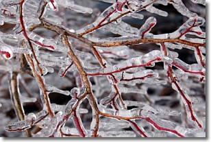
Freezing rain is a condition where precipitation which has fallen in the form of
water droplets reaches temperatures which are below freezing and freezes upon
coming into contact
with surface objects. The result of this precipitation is a glaze of ice which
can be damaging to plants and man-made structures. A severe onset of freezing
rain which results in a very thick glaze of ice is known as an ice storm.
Next Topic: Graupel
Weather Topic: What is Hail?
Home - Education - Precipitation - Hail
 Next Topic: Hole Punch Clouds
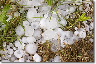
Hail is a form of precipitation which is recognized by large solid balls or
clumps of ice. Hail is created by thunderstorm clouds with strong updrafts of wind.
As the hailstones remain in the updraft, ice is deposited onto them until their
weight becomes heavy enough for them to fall to the earth's surface.
Hail storms can cause significant damage to crops, aircrafts, and man-made structures,
despite the fact that the duration is usually less than ten minutes.
Next Topic: Hole Punch Clouds
Current conditions powered by WeatherAPI.com


