Weather Alert in California
Flood Advisory issued February 24 at 5:02PM PST until February 24 at 10:00PM PST by NWS Eureka CA
AREAS AFFECTED: Lake, CA; Mendocino, CA
DESCRIPTION: * WHAT...Urban area and small stream flooding caused by excessive rainfall is expected. * WHERE...Lake County in central California... Mendocino County in northwestern California... * WHEN...Until 1000 PM PST. * IMPACTS...Minor flooding in low-lying and poor drainage areas. Water over roadways. Ponding of water in urban or other areas is occurring or is imminent. There will be an increased risk of rock and land slides along roadways. * ADDITIONAL DETAILS... - At 502 PM PST, Doppler radar and automated rain gauges indicated heavy rain. This is causing urban and small stream flooding. Between 2 and 5 inches of rain have fallen. - Additional rainfall amounts of 0.3 to 1 inch are expected over the area. This additional rain will result in minor flooding. - Some locations that will experience flooding include... Ukiah, Lakeport, Point Arena, Ukiah Municipal Airport, Upper Lake, Middletown, Clearlake, Knobcone Camp, Hopland, Witter Springs, Saratoga Springs, North Lakeport, Boonville, Philo, Finley, Soda Bay, Mount Konocti, Glenhaven, Konocti Bay and Loch Lomond. - http://www.weather.gov/safety/flood
INSTRUCTION: Turn around, don't drown when encountering flooded roads. Most flood deaths occur in vehicles. Be aware of your surroundings and do not drive on flooded roads.
Want more detail? Get the Complete 7 Day and Night Detailed Forecast!
Current U.S. National Radar--Current
The Current National Weather Radar is shown below with a UTC Time (subtract 5 hours from UTC to get Eastern Time).

National Weather Forecast--Current
The Current National Weather Forecast and National Weather Map are shown below.

National Weather Forecast for Tomorrow
Tomorrow National Weather Forecast and Tomorrow National Weather Map are show below.

North America Water Vapor (Moisture)
This map shows recent moisture content over North America. Bright and colored areas show high moisture (ie, clouds); brown indicates very little moisture present; black indicates no moisture.

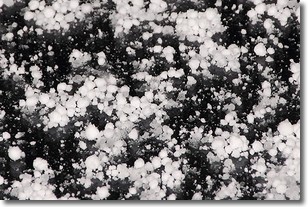
Weather Topic: What is Graupel?
Home - Education - Precipitation - Graupel
 Next Topic: Hail
Graupel is a form of precipitation that is created by atmospheric conditions
which cause supercooled water droplets to contact snow crystals and freeze to
their surface.
Sometimes known as soft hail or snow pellets, graupel is delicate and easily
destroyed by touch. Whereas hail usually falls during severe weather, graupel
doesn't require such conditions to form, and can form in mild precipitation
similar to situations which produce snowfall.
Next Topic: Hail
Weather Topic: What are Hole Punch Clouds?
Home - Education - Cloud Types - Hole Punch Clouds
 Next Topic: Mammatus Clouds
A hole punch cloud is an unusual occurrence when a disk-shaped
hole appears in a cirrostratus, cirrocumulus, or altocumulus cloud.
When part of the cloud forms ice crystals, water droplets in the surrounding area
of the cloud evaporate. The effect of this process produces a large elliptical
gap in the cloud. The hole punch cloud formation is rare, but it is not specific
to any geographic area.
Other names which have been used to describe this phenomena include fallstreak hole,
skypunch, and cloud hole.
Next Topic: Mammatus Clouds
Current conditions powered by WeatherAPI.com


