Weather Alert in California
Flood Advisory issued February 24 at 5:02PM PST until February 24 at 10:00PM PST by NWS Eureka CA
AREAS AFFECTED: Lake, CA; Mendocino, CA
DESCRIPTION: * WHAT...Urban area and small stream flooding caused by excessive rainfall is expected. * WHERE...Lake County in central California... Mendocino County in northwestern California... * WHEN...Until 1000 PM PST. * IMPACTS...Minor flooding in low-lying and poor drainage areas. Water over roadways. Ponding of water in urban or other areas is occurring or is imminent. There will be an increased risk of rock and land slides along roadways. * ADDITIONAL DETAILS... - At 502 PM PST, Doppler radar and automated rain gauges indicated heavy rain. This is causing urban and small stream flooding. Between 2 and 5 inches of rain have fallen. - Additional rainfall amounts of 0.3 to 1 inch are expected over the area. This additional rain will result in minor flooding. - Some locations that will experience flooding include... Ukiah, Lakeport, Point Arena, Ukiah Municipal Airport, Upper Lake, Middletown, Clearlake, Knobcone Camp, Hopland, Witter Springs, Saratoga Springs, North Lakeport, Boonville, Philo, Finley, Soda Bay, Mount Konocti, Glenhaven, Konocti Bay and Loch Lomond. - http://www.weather.gov/safety/flood
INSTRUCTION: Turn around, don't drown when encountering flooded roads. Most flood deaths occur in vehicles. Be aware of your surroundings and do not drive on flooded roads.
Want more detail? Get the Complete 7 Day and Night Detailed Forecast!
Current U.S. National Radar--Current
The Current National Weather Radar is shown below with a UTC Time (subtract 5 hours from UTC to get Eastern Time).

National Weather Forecast--Current
The Current National Weather Forecast and National Weather Map are shown below.

National Weather Forecast for Tomorrow
Tomorrow National Weather Forecast and Tomorrow National Weather Map are show below.

North America Water Vapor (Moisture)
This map shows recent moisture content over North America. Bright and colored areas show high moisture (ie, clouds); brown indicates very little moisture present; black indicates no moisture.

Weather Topic: What is Fog?
Home - Education - Cloud Types - Fog
 Next Topic: Fractus Clouds
Fog is technically a type of stratus cloud, which lies along the
ground and obscures visibility.
It is usually created when humidity in the air condenses into tiny water droplets.
Because of this, some places are more prone to foggy weather, such as regions
close to a body of water.
Fog is similar to mist; both are the appearance of water droplets suspended in
the air, but fog is the term applied to the condition when visibility is less than 1 km.
Next Topic: Fractus Clouds
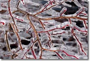
Weather Topic: What is Freezing Rain?
Home - Education - Precipitation - Freezing Rain
 Next Topic: Graupel
Freezing rain is a condition where precipitation which has fallen in the form of
water droplets reaches temperatures which are below freezing and freezes upon
coming into contact
with surface objects. The result of this precipitation is a glaze of ice which
can be damaging to plants and man-made structures. A severe onset of freezing
rain which results in a very thick glaze of ice is known as an ice storm.
Next Topic: Graupel
Current conditions powered by WeatherAPI.com


