Weather Alert in North Carolina
Tropical Storm Warning issued August 20 at 10:50PM EDT by NWS Wakefield VA
AREAS AFFECTED: Western Currituck
DESCRIPTION: * LOCATIONS AFFECTED - Aydlett - Currituck * WIND - LATEST LOCAL FORECAST: Below tropical storm force wind - Peak Wind Forecast: 25-35 mph with gusts to 50 mph - THREAT TO LIFE AND PROPERTY THAT INCLUDES TYPICAL FORECAST UNCERTAINTY IN TRACK, SIZE AND INTENSITY: Potential for wind 39 to 57 mph - The wind threat has remained nearly steady from the previous assessment. - PLAN: Plan for hazardous wind of equivalent tropical storm force. - PREPARE: Efforts to protect property should now be underway. Prepare for limited wind damage. - ACT: Act now to complete preparations before the wind becomes hazardous. - POTENTIAL IMPACTS: Limited - Damage to porches, awnings, carports, sheds, and unanchored mobile homes. Unsecured lightweight objects blown about. - Many large tree limbs broken off. A few trees snapped or uprooted, especially if soils are saturated. Some roadway signs will sustain damage. - A few roads will be impassable from debris. Hazardous driving conditions on bridges and other elevated roadways. - Scattered power and communications outages. * STORM SURGE - LATEST LOCAL FORECAST: Localized storm surge possible - Peak Storm Surge Inundation: The potential for 1-3 feet above ground somewhere within surge prone areas - Window of concern: through Friday evening - THREAT TO LIFE AND PROPERTY THAT INCLUDES TYPICAL FORECAST UNCERTAINTY IN TRACK, SIZE AND INTENSITY: Potential for storm surge flooding greater than 1 foot above ground - The storm surge threat has remained nearly steady from the previous assessment. - PLAN: Shelter against storm surge flooding greater than 1 foot above ground. - PREPARE: All flood preparations should be complete. Expect flooding of low-lying roads and property. - ACT: Stay away from storm surge prone areas. Continue to follow the instructions of local officials. - POTENTIAL IMPACTS: Unfolding - Potential impacts from the main surge event are unfolding. * FLOODING RAIN - LATEST LOCAL FORECAST: - Peak Rainfall Amounts: No additional significant rainfall forecast - THREAT TO LIFE AND PROPERTY THAT INCLUDES TYPICAL FORECAST UNCERTAINTY IN TRACK, SIZE AND INTENSITY: Little or no potential for flooding rain - The flooding rain threat has remained nearly steady from the previous assessment. - PLAN: There is little or no potential for flooding rain. - PREPARE: Little to no preparations are needed to protect against flooding rain at this time. - ACT: Monitor for changes to the forecast. - POTENTIAL IMPACTS: Little to None - Little to no potential impacts from flooding rain. * TORNADO - LATEST LOCAL FORECAST: - Situation is unfavorable for tornadoes - THREAT TO LIFE AND PROPERTY THAT INCLUDES TYPICAL FORECAST UNCERTAINTY IN TRACK, SIZE AND INTENSITY: Tornadoes not expected - The tornado threat has remained nearly steady from the previous assessment. - PLAN: Tornadoes are not expected. Showers and thunderstorms with gusty winds may still occur. - PREPARE: Little to no preparations needed to protect against tornadoes at this time. Keep informed of the latest tornado situation. - ACT: Listen for changes in the forecast. - POTENTIAL IMPACTS: Little to None - Little to no potential impacts from tornadoes. * FOR MORE INFORMATION: - http://ready.gov/hurricanes - readync.org - weather.gov/akq
INSTRUCTION: N/A
Want more detail? Get the Complete 7 Day and Night Detailed Forecast!
Current U.S. National Radar--Current
The Current National Weather Radar is shown below with a UTC Time (subtract 5 hours from UTC to get Eastern Time).

National Weather Forecast--Current
The Current National Weather Forecast and National Weather Map are shown below.

National Weather Forecast for Tomorrow
Tomorrow National Weather Forecast and Tomorrow National Weather Map are show below.

North America Water Vapor (Moisture)
This map shows recent moisture content over North America. Bright and colored areas show high moisture (ie, clouds); brown indicates very little moisture present; black indicates no moisture.

Weather Topic: What is Sleet?
Home - Education - Precipitation - Sleet
 Next Topic: Snow
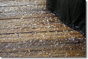
Sleet is a form of precipitation in which small ice pellets are the primary
components. These ice pellets are smaller and more translucent than hailstones,
and harder than graupel. Sleet is caused by specific atmospheric conditions and
therefore typically doesn't last for extended periods of time.
The condition which leads to sleet formation requires a warmer body of air to be
wedged in between two sub-freezing bodies of air. When snow falls through a warmer
layer of air it melts, and as it falls through the next sub-freezing body of air
it freezes again, forming ice pellets known as sleet. In some cases, water
droplets don't have time to freeze before reaching the surface and the result is
freezing rain.
Next Topic: Snow
Weather Topic: What are Stratocumulus Clouds?
Home - Education - Cloud Types - Stratocumulus Clouds
 Next Topic: Stratus Clouds
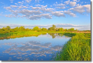
Stratocumulus clouds are similar to altocumulus clouds in their
fluffy appearance, but have a slightly darker shade due to their additional mass.
A good way to distinguish the two cloud types is to hold your hand out and measure
the size of an individual cloud; if it is the size of your thumb it is generally
an altocumulus cloud, if it is the size of your hand it is generally a
stratocumulus cloud.
It is uncommon for stratocumulus clouds to produce precipitation, but if they do
it is usually a light rain or snow.
Next Topic: Stratus Clouds
Current conditions powered by WeatherAPI.com


