Weather Alert in California
Special Weather Statement issued July 30 at 3:29AM PDT by NWS San Francisco CA
AREAS AFFECTED: San Francisco; Coastal North Bay Including Point Reyes National Seashore; North Bay Interior Valleys; San Francisco Bay Shoreline; San Francisco Peninsula Coast; Northern Monterey Bay; Southern Monterey Bay and Big Sur Coast
DESCRIPTION: ...TSUNAMI ADVISORY IS IN EFFECT FROM THE SONOMA COASTLINE DOWN THROUGH THE BIG SUR COASTLINE INCLUDING SF AND MONTEREY BAY... *UPDATES...The following tsunami waves have been observed: LocationTimeMax Amplitude Pt. Reyes 0056 0.8 ft San Francisco 0117 0.8 ft Monterey 0051 1.1 ft * LOCAL IMPACTs...Dangerous currents and fast tidal swings will persist through the morning due to impacts from an ongoing tsunami event. These conditions are hazardous to swimmers, boats, and coastal structures. Widespread inundation is NOT expected. However, damage at the harbors is possible. Surging water in and out of harbors and changing water levels can cause boats and docks to detach from structures. * RECOMMENDED ACTIONS...If you are located in this coastal area, move off the beach and out of harbors and marinas. Do not go to the coast to watch the tsunami. Be alert to instructions from your local emergency officials. Tsunamis often arrive as a series of waves or surges which could be dangerous for many hours after the first wave arrival. The first tsunami wave or surge may not be the highest in the series. * PRELIMINARY EARTHQUAKE INFORMATION...An earthquake occurred with a magnitude of 8.8 off the coast of the Kamchatka Peninsula in Russia at 2324 UTC July 29, 2025. This product will be updated as new information becomes available. Stay tuned to your local news source and NOAA weather radio for further information and updates.
INSTRUCTION: N/A
Want more detail? Get the Complete 7 Day and Night Detailed Forecast!
Current U.S. National Radar--Current
The Current National Weather Radar is shown below with a UTC Time (subtract 5 hours from UTC to get Eastern Time).

National Weather Forecast--Current
The Current National Weather Forecast and National Weather Map are shown below.

National Weather Forecast for Tomorrow
Tomorrow National Weather Forecast and Tomorrow National Weather Map are show below.

North America Water Vapor (Moisture)
This map shows recent moisture content over North America. Bright and colored areas show high moisture (ie, clouds); brown indicates very little moisture present; black indicates no moisture.

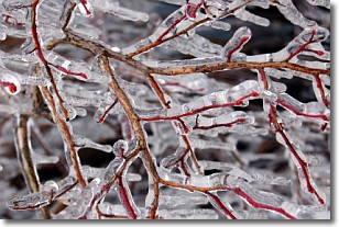
Weather Topic: What is Freezing Rain?
Home - Education - Precipitation - Freezing Rain
 Next Topic: Graupel
Freezing rain is a condition where precipitation which has fallen in the form of
water droplets reaches temperatures which are below freezing and freezes upon
coming into contact
with surface objects. The result of this precipitation is a glaze of ice which
can be damaging to plants and man-made structures. A severe onset of freezing
rain which results in a very thick glaze of ice is known as an ice storm.
Next Topic: Graupel
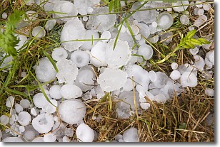
Weather Topic: What is Hail?
Home - Education - Precipitation - Hail
 Next Topic: Hole Punch Clouds
Hail is a form of precipitation which is recognized by large solid balls or
clumps of ice. Hail is created by thunderstorm clouds with strong updrafts of wind.
As the hailstones remain in the updraft, ice is deposited onto them until their
weight becomes heavy enough for them to fall to the earth's surface.
Hail storms can cause significant damage to crops, aircrafts, and man-made structures,
despite the fact that the duration is usually less than ten minutes.
Next Topic: Hole Punch Clouds
Current conditions powered by WeatherAPI.com


