Weather Alert in South Carolina
Flash Flood Warning issued August 22 at 4:10PM EDT until August 22 at 8:15PM EDT by NWS Charleston SC
AREAS AFFECTED: Berkeley, SC; Charleston, SC; Dorchester, SC
DESCRIPTION: FFWCHS The National Weather Service in Charleston has extended the * Flash Flood Warning for... Berkeley County in southeastern South Carolina... Charleston County in southeastern South Carolina... Dorchester County in southeastern South Carolina... * Until 815 PM EDT. * At 410 PM EDT, emergency management officials reported flash flooding is still ongoing across much of the Charleston Metro Area. Many roads are reported closed and flooded across Downtown Charleston, North Charleston and surrounding communities. Radar shows heavy rain expanding across the Metro area again. This will worsen ongoing flash flooding. As much as 3 to 5 inches have fallen so far today. An additional 1 to 3 inches could fall through 815 PM, resulting in continued flash flooding. HAZARD...Life threatening flash flooding. Thunderstorms producing flash flooding. SOURCE...Emergency management reported. IMPACT...Life threatening flash flooding of creeks and streams, urban areas, highways, streets and underpasses. * Some locations that will experience flash flooding include... North Charleston, Mount Pleasant, Goose Creek, Hanahan, West Ashley, Downtown Charleston, I-26/I-526 Interchange, James Island, Johns Island and Daniel Island. This includes the following highways... I-26 between mile markers 208 and 221. I-526 between mile markers 11 and 29.
INSTRUCTION: Turn around, don't drown when encountering flooded roads. Most flood deaths occur in vehicles. Report flooding directly to the Charleston National Weather Service at 1-888-383-2024 or email your reports to nws.charlestonsc@noaa.gov.
Want more detail? Get the Complete 7 Day and Night Detailed Forecast!
Current U.S. National Radar--Current
The Current National Weather Radar is shown below with a UTC Time (subtract 5 hours from UTC to get Eastern Time).

National Weather Forecast--Current
The Current National Weather Forecast and National Weather Map are shown below.

National Weather Forecast for Tomorrow
Tomorrow National Weather Forecast and Tomorrow National Weather Map are show below.

North America Water Vapor (Moisture)
This map shows recent moisture content over North America. Bright and colored areas show high moisture (ie, clouds); brown indicates very little moisture present; black indicates no moisture.

Weather Topic: What is Hail?
Home - Education - Precipitation - Hail
 Next Topic: Hole Punch Clouds
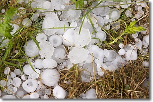
Hail is a form of precipitation which is recognized by large solid balls or
clumps of ice. Hail is created by thunderstorm clouds with strong updrafts of wind.
As the hailstones remain in the updraft, ice is deposited onto them until their
weight becomes heavy enough for them to fall to the earth's surface.
Hail storms can cause significant damage to crops, aircrafts, and man-made structures,
despite the fact that the duration is usually less than ten minutes.
Next Topic: Hole Punch Clouds
Weather Topic: What are Mammatus Clouds?
Home - Education - Cloud Types - Mammatus Clouds
 Next Topic: Nimbostratus Clouds
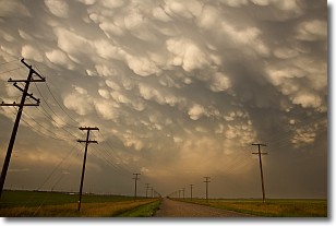
A mammatus cloud is a cloud with a unique feature which resembles
a web of pouches hanging along the base of the cloud.
In the United States, mammatus clouds tend to form in the warmer months, commonly
in the Midwest and eastern regions.
While they usually form at the bottom of a cumulonimbis cloud, they can also form
under altostratus, altocumulus, stratocumulus, and cirrus clouds. Mammatus clouds
warn that severe weather is close.
Next Topic: Nimbostratus Clouds
Current conditions powered by WeatherAPI.com


