Weather Alert in Mississippi
Special Weather Statement issued September 6 at 5:10AM CDT by NWS Jackson MS
AREAS AFFECTED: Leflore; Grenada; Carroll; Montgomery; Holmes
DESCRIPTION: At 507 AM CDT, Doppler radar was tracking an outflow boundary producing gusty winds along a line extending from 7 miles northwest of Leflore to near Thornton. Movement was east at 40 mph. HAZARD...Wind gusts up to 40 mph. SOURCE...Radar indicated. IMPACT...Gusty winds could knock down tree limbs and blow around unsecured objects. Gusty winds will affect... Greenwood, Tchula, Holcomb, Avalon, Seven Pines, Tolarville, Teoc, Howard, and Leflore around 515 AM CDT. Malmaison and Bew Springs around 520 AM CDT. Grenada, Carrollton, Jefferson, North Carrollton, Black Hawk, Coila, and Brozville around 525 AM CDT. Lexington around 530 AM CDT.
INSTRUCTION: If outdoors, consider seeking shelter inside a building. High winds can bring down trees and large limbs resulting in serious injury or property damage. Exercise extreme caution when outdoors during such strong winds...and be especially aware of older trees. If on or near Grenada Lake, get out of the water and move indoors or inside a vehicle. Boats could be damaged or overturned in high winds and suddenly higher waves. Move to safe shelter now!
Want more detail? Get the Complete 7 Day and Night Detailed Forecast!
Current U.S. National Radar--Current
The Current National Weather Radar is shown below with a UTC Time (subtract 5 hours from UTC to get Eastern Time).

National Weather Forecast--Current
The Current National Weather Forecast and National Weather Map are shown below.

National Weather Forecast for Tomorrow
Tomorrow National Weather Forecast and Tomorrow National Weather Map are show below.

North America Water Vapor (Moisture)
This map shows recent moisture content over North America. Bright and colored areas show high moisture (ie, clouds); brown indicates very little moisture present; black indicates no moisture.

Weather Topic: What are Fractus Clouds?
Home - Education - Cloud Types - Fractus Clouds
 Next Topic: Freezing Rain
A fractus cloud (scud) is a fragmented, tattered cloud which has
likely been sheared off of another cloud. They are accessory clouds, meaning they
develop from parent clouds, and are named in a way which describes the original
cloud which contained them.
Fractus clouds which have originated from cumulus clouds are referred to as
cumulus fractus, while fractus clouds which have originated from stratus clouds
are referred to as stratus fractus. Under certain conditions a fractus cloud might
merge with another cloud, or develop into a cumulus cloud, but usually a
fractus cloud seen by itself will dissipate rapidly.
They are often observed on the leading and trailing edges of storm clouds,
and are a display of wind activity.
Next Topic: Freezing Rain
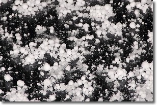
Weather Topic: What is Graupel?
Home - Education - Precipitation - Graupel
 Next Topic: Hail
Graupel is a form of precipitation that is created by atmospheric conditions
which cause supercooled water droplets to contact snow crystals and freeze to
their surface.
Sometimes known as soft hail or snow pellets, graupel is delicate and easily
destroyed by touch. Whereas hail usually falls during severe weather, graupel
doesn't require such conditions to form, and can form in mild precipitation
similar to situations which produce snowfall.
Next Topic: Hail
Current conditions powered by WeatherAPI.com


