Weather Alert in Texas
Special Weather Statement issued August 12 at 1:53AM CDT by NWS San Angelo TX
AREAS AFFECTED: Throckmorton; Jones; Shackelford; Taylor; Callahan
DESCRIPTION: At 149 AM CDT, Doppler radar was tracking a line of strong winds moving away from thunderstorms in Haskell, Fisher, and Jones counties. The outflow boundary is moving through Anson and Lueders, moving southeast at 30 mph. HAZARD...Wind gusts up to 55 mph. SOURCE...Radar indicated. IMPACT...Gusty winds could knock down tree limbs and blow around unsecured objects. Locations impacted include... Abilene, Anson, Albany, Tye, Hawley, Lueders, Moran, Ibex, Hamby, Nugent, Avoca, Fort Griffin, Dyess Afb, Impact, Funston, Mccarty Lake, Lake Fort Phantom Hill, Us-283 Near The Callahan- Shackelford County Line, Us-180 Near The Shackelford- Stephens County Line, and The Intersection Of Us- 180 And Farm Road 600. This includes Interstate 20 between Mile Markers 273 and 300.
INSTRUCTION: If outdoors, consider seeking shelter inside a building.
Want more detail? Get the Complete 7 Day and Night Detailed Forecast!
Current U.S. National Radar--Current
The Current National Weather Radar is shown below with a UTC Time (subtract 5 hours from UTC to get Eastern Time).

National Weather Forecast--Current
The Current National Weather Forecast and National Weather Map are shown below.

National Weather Forecast for Tomorrow
Tomorrow National Weather Forecast and Tomorrow National Weather Map are show below.

North America Water Vapor (Moisture)
This map shows recent moisture content over North America. Bright and colored areas show high moisture (ie, clouds); brown indicates very little moisture present; black indicates no moisture.

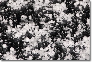
Weather Topic: What is Graupel?
Home - Education - Precipitation - Graupel
 Next Topic: Hail
Graupel is a form of precipitation that is created by atmospheric conditions
which cause supercooled water droplets to contact snow crystals and freeze to
their surface.
Sometimes known as soft hail or snow pellets, graupel is delicate and easily
destroyed by touch. Whereas hail usually falls during severe weather, graupel
doesn't require such conditions to form, and can form in mild precipitation
similar to situations which produce snowfall.
Next Topic: Hail
Weather Topic: What are Hole Punch Clouds?
Home - Education - Cloud Types - Hole Punch Clouds
 Next Topic: Mammatus Clouds
A hole punch cloud is an unusual occurrence when a disk-shaped
hole appears in a cirrostratus, cirrocumulus, or altocumulus cloud.
When part of the cloud forms ice crystals, water droplets in the surrounding area
of the cloud evaporate. The effect of this process produces a large elliptical
gap in the cloud. The hole punch cloud formation is rare, but it is not specific
to any geographic area.
Other names which have been used to describe this phenomena include fallstreak hole,
skypunch, and cloud hole.
Next Topic: Mammatus Clouds
Current conditions powered by WeatherAPI.com


