Weather Alert in Illinois
Special Weather Statement issued July 25 at 10:05AM CDT by NWS Chicago IL
AREAS AFFECTED: La Salle; Kendall; Grundy; Kankakee; Livingston; Southern Cook; Northern Will; Southern Will; Eastern Will
DESCRIPTION: Atmospheric conditions are favorable for the development of funnel clouds. These funnel clouds normally only protrude a few hundred feet downward from the parent cloud, rotate or spin like a top, and last a few minutes before dissipating. These funnel clouds rarely touch the ground and typically do not pose any sort of hazard. The atmospheric conditions that these funnel clouds develop in do not support strong, damaging tornadoes. However, on extremely rare occasions, these funnels can briefly touch the ground and produce very minimal, if any, damage. If threatening weather approaches, move indoors to a place of safety. The National Weather Service will continue to closely monitor the situation.
INSTRUCTION: N/A
Want more detail? Get the Complete 7 Day and Night Detailed Forecast!
Current U.S. National Radar--Current
The Current National Weather Radar is shown below with a UTC Time (subtract 5 hours from UTC to get Eastern Time).

National Weather Forecast--Current
The Current National Weather Forecast and National Weather Map are shown below.

National Weather Forecast for Tomorrow
Tomorrow National Weather Forecast and Tomorrow National Weather Map are show below.

North America Water Vapor (Moisture)
This map shows recent moisture content over North America. Bright and colored areas show high moisture (ie, clouds); brown indicates very little moisture present; black indicates no moisture.

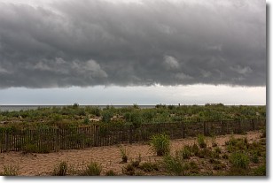
Weather Topic: What are Shelf Clouds?
Home - Education - Cloud Types - Shelf Clouds
 Next Topic: Sleet
A shelf cloud is similar to a wall cloud, but forms at the front
of a storm cloud, instead of at the rear, where wall clouds form.
A shelf cloud is caused by a series of events set into motion by the advancing
storm; first, cool air settles along the ground where precipitation has just fallen.
As the cool air is brought in, the warmer air is displaced, and rises above it,
because it is less dense. When the warmer air reaches the bottom of the storm cloud,
it begins to cool again, and the resulting condensation is a visible shelf cloud.
Next Topic: Sleet
Weather Topic: What is Snow?
Home - Education - Precipitation - Snow
 Next Topic: Stratocumulus Clouds
Snow is precipitation taking the form of ice crystals. Each ice crystal, or snowflake,
has unique characteristics, but all of them grow in a hexagonal structure.
Snowfall can last for sustained periods of time and result in significant buildup
of snow on the ground.
On the earth's surface, snow starts out light and powdery, but as it begins to melt
it tends to become more granular, producing small bits of ice which have the consistency of
sand. After several cycles of melting and freezing, snow can become very dense
and ice-like, commonly known as snow pack.
Next Topic: Stratocumulus Clouds
Current conditions powered by WeatherAPI.com


