Weather Alert in Minnesota
Flood Warning issued August 22 at 9:51AM CDT by NWS Twin Cities/Chanhassen MN
AREAS AFFECTED: Carver, MN; Scott, MN; Sibley, MN
DESCRIPTION: ...The National Weather Service in the Twin Cities has issued a Flood Warning for the following rivers in Minnesota... Minnesota River at Henderson MN19 affecting Sibley, Le Sueur and Scott Counties. Minnesota River near Jordan affecting Sibley, Scott and Carver Counties. ...Forecast flooding changed from Minor to Moderate severity for the following rivers in Minnesota... Minnesota River at Montevideo affecting Chippewa, Yellow Medicine and Lac qui Parle Counties. .As water from storms over the past few weeks continue to move through the Minnesota River more points will rise above flood stage. Based on current forecasts additional warnings downriver are not anticipated. * WHAT...Minor flooding is forecast. * WHERE...Minnesota River near Jordan. * WHEN...From late Saturday night until further notice. * IMPACTS...At 25.0 feet, Low lying areas and some roads along the river begin to flood and private sanitary sewers may experience problems. * ADDITIONAL DETAILS... - At 845 AM CDT Friday, the stage was 23.4 feet. - Forecast...The river is expected to rise above flood stage early Sunday morning and continue rising to a crest of 25.6 feet early Tuesday morning. - Flood stage is 25.0 feet. - Flood History...This crest compares to a previous crest of 25.6 feet on 06/12/1991.
INSTRUCTION: Turn around, don't drown when encountering flooded roads. Most flood deaths occur in vehicles. Please report observed flooding to local emergency services or law enforcement and request they pass this information to the National Weather Service when you can do so safely.
Want more detail? Get the Complete 7 Day and Night Detailed Forecast!
Current U.S. National Radar--Current
The Current National Weather Radar is shown below with a UTC Time (subtract 5 hours from UTC to get Eastern Time).

National Weather Forecast--Current
The Current National Weather Forecast and National Weather Map are shown below.

National Weather Forecast for Tomorrow
Tomorrow National Weather Forecast and Tomorrow National Weather Map are show below.

North America Water Vapor (Moisture)
This map shows recent moisture content over North America. Bright and colored areas show high moisture (ie, clouds); brown indicates very little moisture present; black indicates no moisture.

Weather Topic: What is Fog?
Home - Education - Cloud Types - Fog
 Next Topic: Fractus Clouds
Fog is technically a type of stratus cloud, which lies along the
ground and obscures visibility.
It is usually created when humidity in the air condenses into tiny water droplets.
Because of this, some places are more prone to foggy weather, such as regions
close to a body of water.
Fog is similar to mist; both are the appearance of water droplets suspended in
the air, but fog is the term applied to the condition when visibility is less than 1 km.
Next Topic: Fractus Clouds
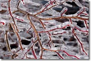
Weather Topic: What is Freezing Rain?
Home - Education - Precipitation - Freezing Rain
 Next Topic: Graupel
Freezing rain is a condition where precipitation which has fallen in the form of
water droplets reaches temperatures which are below freezing and freezes upon
coming into contact
with surface objects. The result of this precipitation is a glaze of ice which
can be damaging to plants and man-made structures. A severe onset of freezing
rain which results in a very thick glaze of ice is known as an ice storm.
Next Topic: Graupel
Current conditions powered by WeatherAPI.com


