Weather Alert in Minnesota
Flood Warning issued August 22 at 9:51AM CDT by NWS Twin Cities/Chanhassen MN
AREAS AFFECTED: Carver, MN; Scott, MN; Sibley, MN
DESCRIPTION: ...The National Weather Service in the Twin Cities has issued a Flood Warning for the following rivers in Minnesota... Minnesota River at Henderson MN19 affecting Sibley, Le Sueur and Scott Counties. Minnesota River near Jordan affecting Sibley, Scott and Carver Counties. ...Forecast flooding changed from Minor to Moderate severity for the following rivers in Minnesota... Minnesota River at Montevideo affecting Chippewa, Yellow Medicine and Lac qui Parle Counties. .As water from storms over the past few weeks continue to move through the Minnesota River more points will rise above flood stage. Based on current forecasts additional warnings downriver are not anticipated. * WHAT...Minor flooding is forecast. * WHERE...Minnesota River near Jordan. * WHEN...From late Saturday night until further notice. * IMPACTS...At 25.0 feet, Low lying areas and some roads along the river begin to flood and private sanitary sewers may experience problems. * ADDITIONAL DETAILS... - At 845 AM CDT Friday, the stage was 23.4 feet. - Forecast...The river is expected to rise above flood stage early Sunday morning and continue rising to a crest of 25.6 feet early Tuesday morning. - Flood stage is 25.0 feet. - Flood History...This crest compares to a previous crest of 25.6 feet on 06/12/1991.
INSTRUCTION: Turn around, don't drown when encountering flooded roads. Most flood deaths occur in vehicles. Please report observed flooding to local emergency services or law enforcement and request they pass this information to the National Weather Service when you can do so safely.
Want more detail? Get the Complete 7 Day and Night Detailed Forecast!
Current U.S. National Radar--Current
The Current National Weather Radar is shown below with a UTC Time (subtract 5 hours from UTC to get Eastern Time).

National Weather Forecast--Current
The Current National Weather Forecast and National Weather Map are shown below.

National Weather Forecast for Tomorrow
Tomorrow National Weather Forecast and Tomorrow National Weather Map are show below.

North America Water Vapor (Moisture)
This map shows recent moisture content over North America. Bright and colored areas show high moisture (ie, clouds); brown indicates very little moisture present; black indicates no moisture.

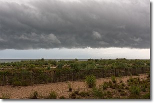
Weather Topic: What are Shelf Clouds?
Home - Education - Cloud Types - Shelf Clouds
 Next Topic: Sleet
A shelf cloud is similar to a wall cloud, but forms at the front
of a storm cloud, instead of at the rear, where wall clouds form.
A shelf cloud is caused by a series of events set into motion by the advancing
storm; first, cool air settles along the ground where precipitation has just fallen.
As the cool air is brought in, the warmer air is displaced, and rises above it,
because it is less dense. When the warmer air reaches the bottom of the storm cloud,
it begins to cool again, and the resulting condensation is a visible shelf cloud.
Next Topic: Sleet
Weather Topic: What is Snow?
Home - Education - Precipitation - Snow
 Next Topic: Stratocumulus Clouds
Snow is precipitation taking the form of ice crystals. Each ice crystal, or snowflake,
has unique characteristics, but all of them grow in a hexagonal structure.
Snowfall can last for sustained periods of time and result in significant buildup
of snow on the ground.
On the earth's surface, snow starts out light and powdery, but as it begins to melt
it tends to become more granular, producing small bits of ice which have the consistency of
sand. After several cycles of melting and freezing, snow can become very dense
and ice-like, commonly known as snow pack.
Next Topic: Stratocumulus Clouds
Current conditions powered by WeatherAPI.com


