Weather Alert in Minnesota
Flood Warning issued August 22 at 9:51AM CDT by NWS Twin Cities/Chanhassen MN
AREAS AFFECTED: Chippewa, MN; Lac qui Parle, MN; Yellow Medicine, MN
DESCRIPTION: ...The National Weather Service in the Twin Cities has issued a Flood Warning for the following rivers in Minnesota... Minnesota River at Henderson MN19 affecting Sibley, Le Sueur and Scott Counties. Minnesota River near Jordan affecting Sibley, Scott and Carver Counties. ...Forecast flooding changed from Minor to Moderate severity for the following rivers in Minnesota... Minnesota River at Montevideo affecting Chippewa, Yellow Medicine and Lac qui Parle Counties. .As water from storms over the past few weeks continue to move through the Minnesota River more points will rise above flood stage. Based on current forecasts additional warnings downriver are not anticipated. * WHAT...Minor flooding is occurring and moderate flooding is forecast. * WHERE...Minnesota River at Montevideo. * WHEN...Until further notice. * IMPACTS...At 17.0 feet, Storm sewers may need to be plugged to prevent water from backing up into streets. * ADDITIONAL DETAILS... - At 900 AM CDT Friday, the stage was 16.0 feet. - Recent Activity...The maximum river stage in the 24 hours ending at 900 AM CDT Friday was 16.0 feet. - Forecast...The river is expected to maintain a crest of 16.0 feet this afternoon. - Flood stage is 14.0 feet. - Flood History...This crest compares to a previous crest of 16.0 feet on 03/25/1994.
INSTRUCTION: Turn around, don't drown when encountering flooded roads. Most flood deaths occur in vehicles. Please report observed flooding to local emergency services or law enforcement and request they pass this information to the National Weather Service when you can do so safely.
Want more detail? Get the Complete 7 Day and Night Detailed Forecast!
Current U.S. National Radar--Current
The Current National Weather Radar is shown below with a UTC Time (subtract 5 hours from UTC to get Eastern Time).

National Weather Forecast--Current
The Current National Weather Forecast and National Weather Map are shown below.

National Weather Forecast for Tomorrow
Tomorrow National Weather Forecast and Tomorrow National Weather Map are show below.

North America Water Vapor (Moisture)
This map shows recent moisture content over North America. Bright and colored areas show high moisture (ie, clouds); brown indicates very little moisture present; black indicates no moisture.

Weather Topic: What are Fractus Clouds?
Home - Education - Cloud Types - Fractus Clouds
 Next Topic: Freezing Rain
A fractus cloud (scud) is a fragmented, tattered cloud which has
likely been sheared off of another cloud. They are accessory clouds, meaning they
develop from parent clouds, and are named in a way which describes the original
cloud which contained them.
Fractus clouds which have originated from cumulus clouds are referred to as
cumulus fractus, while fractus clouds which have originated from stratus clouds
are referred to as stratus fractus. Under certain conditions a fractus cloud might
merge with another cloud, or develop into a cumulus cloud, but usually a
fractus cloud seen by itself will dissipate rapidly.
They are often observed on the leading and trailing edges of storm clouds,
and are a display of wind activity.
Next Topic: Freezing Rain
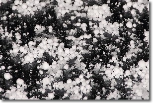
Weather Topic: What is Graupel?
Home - Education - Precipitation - Graupel
 Next Topic: Hail
Graupel is a form of precipitation that is created by atmospheric conditions
which cause supercooled water droplets to contact snow crystals and freeze to
their surface.
Sometimes known as soft hail or snow pellets, graupel is delicate and easily
destroyed by touch. Whereas hail usually falls during severe weather, graupel
doesn't require such conditions to form, and can form in mild precipitation
similar to situations which produce snowfall.
Next Topic: Hail
Current conditions powered by WeatherAPI.com


