Weather Alert in Montana
High Wind Warning issued February 24 at 1:15PM MST until February 25 at 11:00PM MST by NWS Great Falls MT
AREAS AFFECTED: East Glacier Park Region; Northern High Plains; Southern Rocky Mountain Front; Southern High Plains
DESCRIPTION: * WHAT...For the High Wind Warning, west winds 40 to 50 mph with gusts up to 85 mph expected. For the High Wind Watch, west winds 45 to 55 mph with gusts up to 90 mph possible. Winds may gust over 100 mph at times along the immediate eastern slopes of the Rocky Mountain Front. * WHERE...The Rocky Mountain Front and adjacent foothills and plains. * WHEN...For the High Wind Warning, from 2 AM to 11 PM MST Wednesday. For the High Wind Watch, from Wednesday evening through Friday morning. * IMPACTS...High winds may move loose debris, damage property and cause power outages. Travel could be dangerous, especially for high profile or light weight vehicles. * ADDITIONAL DETAILS...Those operating high profile or light weight vehicles should consider delaying travel.
INSTRUCTION: People are urged to secure loose objects that could be blown around or damaged by the wind. Monitor the latest forecasts and warnings for updates.
Want more detail? Get the Complete 7 Day and Night Detailed Forecast!
Current U.S. National Radar--Current
The Current National Weather Radar is shown below with a UTC Time (subtract 5 hours from UTC to get Eastern Time).

National Weather Forecast--Current
The Current National Weather Forecast and National Weather Map are shown below.

National Weather Forecast for Tomorrow
Tomorrow National Weather Forecast and Tomorrow National Weather Map are show below.

North America Water Vapor (Moisture)
This map shows recent moisture content over North America. Bright and colored areas show high moisture (ie, clouds); brown indicates very little moisture present; black indicates no moisture.

Weather Topic: What is Hail?
Home - Education - Precipitation - Hail
 Next Topic: Hole Punch Clouds
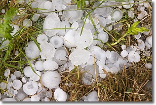
Hail is a form of precipitation which is recognized by large solid balls or
clumps of ice. Hail is created by thunderstorm clouds with strong updrafts of wind.
As the hailstones remain in the updraft, ice is deposited onto them until their
weight becomes heavy enough for them to fall to the earth's surface.
Hail storms can cause significant damage to crops, aircrafts, and man-made structures,
despite the fact that the duration is usually less than ten minutes.
Next Topic: Hole Punch Clouds
Weather Topic: What are Mammatus Clouds?
Home - Education - Cloud Types - Mammatus Clouds
 Next Topic: Nimbostratus Clouds
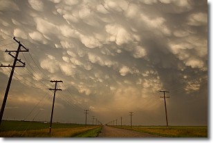
A mammatus cloud is a cloud with a unique feature which resembles
a web of pouches hanging along the base of the cloud.
In the United States, mammatus clouds tend to form in the warmer months, commonly
in the Midwest and eastern regions.
While they usually form at the bottom of a cumulonimbis cloud, they can also form
under altostratus, altocumulus, stratocumulus, and cirrus clouds. Mammatus clouds
warn that severe weather is close.
Next Topic: Nimbostratus Clouds
Current conditions powered by WeatherAPI.com


