Weather Alert in Michigan
Air Quality Alert issued August 1 at 11:55AM EDT by NWS Grand Rapids MI
AREAS AFFECTED: Mason; Lake; Osceola; Clare; Oceana; Newaygo; Mecosta; Isabella; Muskegon; Montcalm; Gratiot; Ottawa; Kent; Ionia; Clinton; Allegan; Barry; Eaton; Ingham; Van Buren; Kalamazoo; Calhoun; Jackson
DESCRIPTION: Air Quality Advisory through Saturday August 2nd... The Michigan Department of Environment, Great Lakes, and Energy (EGLE) has issued an Air Quality Advisory for elevated levels of fine particulate (PM2.5) across the state of Michigan. Smoke from Canadian wildfires remains over the state through Saturday and possibly into Sunday. Pollutants across the state are expected to be in the Unhealthy for Sensitive Groups (USG, Orange AQI) range with some locations reaching the Unhealthy (Red AQI) range. The Air Quality Advisory includes all Michigan counties. It is recommended that, when possible, you avoid strenuous outdoor activities, especially those with heart disease and respiratory diseases like asthma. Monitor for symptoms such as wheezing, coughing, chest tightness, dizziness, or burning in nose, throat, and eyes. Reduce or eliminate activities that contribute to air pollution, such as: outdoor burning, use of residential wood burning devices. Tips for households: Keep windows closed overnight to prevent smoke from getting indoors and, if possible, run central air conditioning with MERV-13 or higher rated filters. For up-to-date air quality data for Michigan visit the MiAir site: https://air-egle.hub.arcgis.com/ For up-to-date air quality data nationally visit EPAs Air Now site: https://www.airnow.gov/ For further health information, please see MDHHS Wildfire Smoke and Your Health site: https://www.michigan.gov/mdhhs/safety-injury-prev/environmental-health/ your-health-and-wildfire-smoke
INSTRUCTION: N/A
Want more detail? Get the Complete 7 Day and Night Detailed Forecast!
Current U.S. National Radar--Current
The Current National Weather Radar is shown below with a UTC Time (subtract 5 hours from UTC to get Eastern Time).

National Weather Forecast--Current
The Current National Weather Forecast and National Weather Map are shown below.

National Weather Forecast for Tomorrow
Tomorrow National Weather Forecast and Tomorrow National Weather Map are show below.

North America Water Vapor (Moisture)
This map shows recent moisture content over North America. Bright and colored areas show high moisture (ie, clouds); brown indicates very little moisture present; black indicates no moisture.

Weather Topic: What are Cirrostratus Clouds?
Home - Education - Cloud Types - Cirrostratus Clouds
 Next Topic: Cirrus Clouds
Cirrostratus clouds are high, thin clouds that form above
20,000 feet and are made mostly of ice crystals. They sometimes look like giant
feathers, horse tails, or curls of hair in the sky.
These clouds are pushed by the jet stream and can move at high speeds reaching
100 mph.
What do they indicate?
They indicate that a precipitation is likely within 24 hours.
Next Topic: Cirrus Clouds
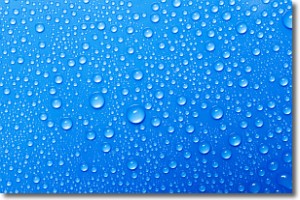
Weather Topic: What is Condensation?
Home - Education - Precipitation - Condensation
 Next Topic: Contrails
Condensation is the process which creates clouds, and therefore
it is a crucial process in the water cycle.
Condensation is the change of matter from a state of gas into a state of liquid,
and it happens because water molecules release heat into the atmosphere and
become organized into a more closely packed structure, what we might see as
water droplets.
Water is always present in the air around us as a vapor, but it's too small for
us to see. When water undergoes the process of condensation it becomes organized
into visible water droplets. You've probably seen condensation happen before on the
surface of a cold drink!
Next Topic: Contrails
Current conditions powered by WeatherAPI.com


