Weather Alert in Arizona
Red Flag Warning issued April 27 at 1:28PM MST until April 27 at 7:00PM MST by NWS Flagstaff AZ
AREAS AFFECTED: Chuska Mountains and Defiance Plateau; Little Colorado River Valley in Coconino County; Little Colorado River Valley in Navajo County; Little Colorado River Valley in Apache County; White Mountains; Northeast Plateaus and Mesas South of Hwy 264
DESCRIPTION: MST Sun Apr 27 2025/ ...RED FLAG WARNING REMAINS IN EFFECT UNTIL 7 PM MST /8 PM MDT/ THIS EVENING FOR THE LITTLE COLORADO RIVER VALLEY, NORTHEAST PLATEAUS AND MESAS SOUTH OF HWY 264, WHITE MOUNTAINS, CHUSKA MOUNTAINS, AND THE DEFIANCE PLATEAU... * AFFECTED AREA...Locations near Alpine, Buffalo Pass, Dilkon, Eagar-Springerville, Ganado, Holbrook, Kykotsmovi, Pinetop- Lakeside, Saint Johns, Show Low, Snowflake-Taylor, Tuba City, Whiteriver, Window Rock and Winslow. This includes portions of the Apache-Sitgreaves National Forest. * WINDS...Southwest 15 to 25 mph with gusts up to 45 mph. * RELATIVE HUMIDITY...As low as 8 percent. * IMPACTS...The combination of gusty winds and low humidity can cause fires to rapidly grow in size and intensity before first responders can contain them.
INSTRUCTION: A Red Flag Warning means that critical fire weather conditions are either occurring or are imminent. A combination of strong winds and low relative humidities can contribute to extreme fire behavior. Please notify field crews of this Red Flag Warning.
Want more detail? Get the Complete 7 Day and Night Detailed Forecast!
Current U.S. National Radar--Current
The Current National Weather Radar is shown below with a UTC Time (subtract 5 hours from UTC to get Eastern Time).

National Weather Forecast--Current
The Current National Weather Forecast and National Weather Map are shown below.

National Weather Forecast for Tomorrow
Tomorrow National Weather Forecast and Tomorrow National Weather Map are show below.

North America Water Vapor (Moisture)
This map shows recent moisture content over North America. Bright and colored areas show high moisture (ie, clouds); brown indicates very little moisture present; black indicates no moisture.

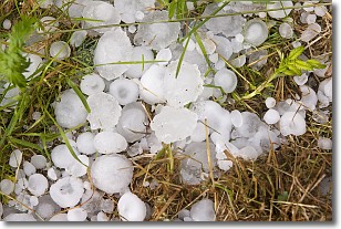
Weather Topic: What is Hail?
Home - Education - Precipitation - Hail
 Next Topic: Hole Punch Clouds
Hail is a form of precipitation which is recognized by large solid balls or
clumps of ice. Hail is created by thunderstorm clouds with strong updrafts of wind.
As the hailstones remain in the updraft, ice is deposited onto them until their
weight becomes heavy enough for them to fall to the earth's surface.
Hail storms can cause significant damage to crops, aircrafts, and man-made structures,
despite the fact that the duration is usually less than ten minutes.
Next Topic: Hole Punch Clouds
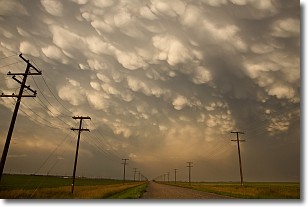
Weather Topic: What are Mammatus Clouds?
Home - Education - Cloud Types - Mammatus Clouds
 Next Topic: Nimbostratus Clouds
A mammatus cloud is a cloud with a unique feature which resembles
a web of pouches hanging along the base of the cloud.
In the United States, mammatus clouds tend to form in the warmer months, commonly
in the Midwest and eastern regions.
While they usually form at the bottom of a cumulonimbis cloud, they can also form
under altostratus, altocumulus, stratocumulus, and cirrus clouds. Mammatus clouds
warn that severe weather is close.
Next Topic: Nimbostratus Clouds
Current conditions powered by WeatherAPI.com


