Weather Alert in Texas
Severe Thunderstorm Warning issued August 2 at 3:06PM CDT until August 2 at 3:30PM CDT by NWS Fort Worth TX
AREAS AFFECTED: Bell, TX
DESCRIPTION: At 305 PM CDT, a severe thunderstorm was located over Temple, moving southeast at 20 mph. HAZARD...60 mph wind gusts and nickel size hail. SOURCE...Trained weather spotters. At 259 PM CDT, a 60 mph wind gust was reported 2 miles east of Morgan's Point Resort. IMPACT...Expect damage to roofs, siding, and trees. This severe storm will be near... Temple around 310 PM CDT. Other locations impacted by this severe thunderstorm include Pendleton, Owl Creek, Moffat, Woodland, and White Hall.
INSTRUCTION: For your protection stay inside a sturdy structure and keep away from windows. Continuous cloud to ground lightning is occurring with this storm. Move indoors immediately. If on or near Belton Lake, get off the water and move indoors or inside a vehicle. Do not be caught on the water in a thunderstorm.
Want more detail? Get the Complete 7 Day and Night Detailed Forecast!
Current U.S. National Radar--Current
The Current National Weather Radar is shown below with a UTC Time (subtract 5 hours from UTC to get Eastern Time).

National Weather Forecast--Current
The Current National Weather Forecast and National Weather Map are shown below.

National Weather Forecast for Tomorrow
Tomorrow National Weather Forecast and Tomorrow National Weather Map are show below.

North America Water Vapor (Moisture)
This map shows recent moisture content over North America. Bright and colored areas show high moisture (ie, clouds); brown indicates very little moisture present; black indicates no moisture.

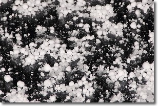
Weather Topic: What is Graupel?
Home - Education - Precipitation - Graupel
 Next Topic: Hail
Graupel is a form of precipitation that is created by atmospheric conditions
which cause supercooled water droplets to contact snow crystals and freeze to
their surface.
Sometimes known as soft hail or snow pellets, graupel is delicate and easily
destroyed by touch. Whereas hail usually falls during severe weather, graupel
doesn't require such conditions to form, and can form in mild precipitation
similar to situations which produce snowfall.
Next Topic: Hail
Weather Topic: What are Hole Punch Clouds?
Home - Education - Cloud Types - Hole Punch Clouds
 Next Topic: Mammatus Clouds
A hole punch cloud is an unusual occurrence when a disk-shaped
hole appears in a cirrostratus, cirrocumulus, or altocumulus cloud.
When part of the cloud forms ice crystals, water droplets in the surrounding area
of the cloud evaporate. The effect of this process produces a large elliptical
gap in the cloud. The hole punch cloud formation is rare, but it is not specific
to any geographic area.
Other names which have been used to describe this phenomena include fallstreak hole,
skypunch, and cloud hole.
Next Topic: Mammatus Clouds
Current conditions powered by WeatherAPI.com


