Weather Alert in Indiana
Flood Warning issued April 3 at 12:58PM EDT by NWS Northern Indiana
AREAS AFFECTED: Pulaski, IN
DESCRIPTION: ...The Flood Warning is extended for the following rivers in Indiana...Ohio... Wabash River near Linn Grove affecting Wells and Adams Counties. Yellow River at Plymouth affecting Starke, St. Joseph and Marshall Counties. Blanchard River at Ottawa affecting Putnam County. Maumee River near Defiance affecting Defiance and Henry Counties. Saint Joseph River Ohio near St. Joe River Ft. Wayne affecting Allen IN County. Saint Joseph River Ohio below Montpelier affecting Williams County. ...The Flood Warning continues for the following rivers in Indiana... Ohio... Tippecanoe River near Ora affecting Pulaski County. Tippecanoe River above Winamac affecting Pulaski, Carroll and White Counties. Eel River at North Manchester affecting Kosciusko, Wabash, Miami, Cass IN and Whitley Counties. Maumee River at Napoleon affecting Henry County. Maumee River at Fort Wayne affecting Paulding and Allen IN Counties. Saint Joseph River Ohio near Newville affecting De Kalb, Defiance and Allen IN Counties. Saint Marys River near Decatur affecting Van Wert, Allen IN and Adams Counties. Tiffin River at Stryker affecting Defiance, Fulton OH and Williams Counties. North Branch Elkhart River at Cosperville affecting Noble County. For the Tippecanoe River...including Ora, Winamac, Norway Dam... Moderate flooding is forecast. For the Wabash River...including Linn Grove, Bluffton IN, Wabash, Logansport...Minor flooding is forecast. For the Eel River...including North Manchester...Minor flooding is forecast. For the Yellow River...including Plymouth, Knox...Minor flooding is forecast. For the Blanchard River...including Ottawa...Minor flooding is forecast. For the Maumee River...including Fort Wayne, Defiance, Napoleon... Minor flooding is forecast. For the Saint Joseph River Ohio...including Montpelier, Newville, St. Joe River Ft. Wayne...Moderate flooding is forecast. For the Saint Marys River...including Decatur, St. Mary's River near Fort Wayne...Minor flooding is forecast. For the Tiffin River...including Stryker...Minor flooding is forecast. For the Elkhart River...including Goshen, Cosperville...Minor flooding is forecast. * WHAT...Minor flooding is occurring and moderate flooding is forecast. * WHERE...Tippecanoe River near Ora. * WHEN...Until further notice. * IMPACTS...At 13.0 feet, Flooding begins to affect streets and homes in Monterey. * ADDITIONAL DETAILS... - At 12:45 PM EDT Friday the stage was 12.5 feet. - Recent Activity...The maximum river stage in the 24 hours ending at 12:45 PM EDT Friday was 12.5 feet. - Forecast...The river is expected to rise to a crest of 13.3 feet early Sunday afternoon. - Flood stage is 12.0 feet. - http://www.weather.gov/safety/flood
INSTRUCTION: Turn around, don't drown when encountering flooded roads. Most flood deaths occur in vehicles. Detailed river forecasts and additional information can be found at www.weather.gov/iwx under Rivers and Lakes. The next statement will be issued Saturday morning at 700 AM EDT /600 AM CDT/.
Want more detail? Get the Complete 7 Day and Night Detailed Forecast!
Current U.S. National Radar--Current
The Current National Weather Radar is shown below with a UTC Time (subtract 5 hours from UTC to get Eastern Time).

National Weather Forecast--Current
The Current National Weather Forecast and National Weather Map are shown below.

National Weather Forecast for Tomorrow
Tomorrow National Weather Forecast and Tomorrow National Weather Map are show below.

North America Water Vapor (Moisture)
This map shows recent moisture content over North America. Bright and colored areas show high moisture (ie, clouds); brown indicates very little moisture present; black indicates no moisture.

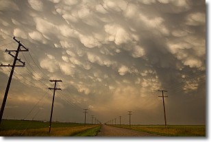
Weather Topic: What are Mammatus Clouds?
Home - Education - Cloud Types - Mammatus Clouds
 Next Topic: Nimbostratus Clouds
A mammatus cloud is a cloud with a unique feature which resembles
a web of pouches hanging along the base of the cloud.
In the United States, mammatus clouds tend to form in the warmer months, commonly
in the Midwest and eastern regions.
While they usually form at the bottom of a cumulonimbis cloud, they can also form
under altostratus, altocumulus, stratocumulus, and cirrus clouds. Mammatus clouds
warn that severe weather is close.
Next Topic: Nimbostratus Clouds
Weather Topic: What is Precipitation?
Home - Education - Precipitation - Precipitation
 Next Topic: Rain
Precipitation can refer to many different forms of water that
may fall from clouds. Precipitation occurs after a cloud has become saturated to
the point where its water particles are more dense than the air below the cloud.
In most cases, precipitation will reach the ground, but it is not uncommon for
precipitation to evaporate before it reaches the earth's surface.
When precipitation evaporates before it contacts the ground it is called Virga.
Graupel, hail, sleet, rain, drizzle, and snow are forms of precipitation, but fog
and mist are not considered precipitation because the water vapor which
constitutes them isn't dense enough to fall to the ground.
Next Topic: Rain
Current conditions powered by WeatherAPI.com


