Weather Alert in Colorado
Air Quality Alert issued August 10 at 4:10PM MDT by NWS Pueblo CO
AREAS AFFECTED: Lake, CO
DESCRIPTION: The Colorado Department of Public Health and Environment has issued the following... WHAT...Air Quality Health Advisory for Wildfire Smoke. WHERE...Gilpin, Clear Creek, Lake, Rio Blanco, Eagle, Summit, Garfield, Pitkin, Gunnison and Grand Counties. Locations include, but are not limited to Central City, Georgetown, Leadville, Meeker, Rangely, Eagle, Vail, Breckenridge, Glenwood Springs, Aspen, Gunnison, Granby, Hot Sulphur Springs and Kremmling. WHEN...900 AM Sunday August 10 to 900 AM Monday August 11 IMPACTS...Smoke from large wildfires in Rio Blanco is impacting a large area of central Colorado. Periods of moderate to heavy smoke are possible throughout the advisory area on Sunday and Monday. HEALTH INFORMATION...There was a problem with the request.
INSTRUCTION: N/A
Want more detail? Get the Complete 7 Day and Night Detailed Forecast!
Current U.S. National Radar--Current
The Current National Weather Radar is shown below with a UTC Time (subtract 5 hours from UTC to get Eastern Time).

National Weather Forecast--Current
The Current National Weather Forecast and National Weather Map are shown below.

National Weather Forecast for Tomorrow
Tomorrow National Weather Forecast and Tomorrow National Weather Map are show below.

North America Water Vapor (Moisture)
This map shows recent moisture content over North America. Bright and colored areas show high moisture (ie, clouds); brown indicates very little moisture present; black indicates no moisture.

Weather Topic: What is Freezing Rain?
Home - Education - Precipitation - Freezing Rain
 Next Topic: Graupel
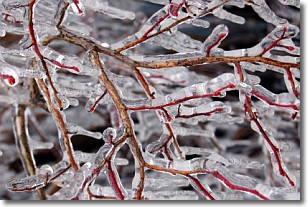
Freezing rain is a condition where precipitation which has fallen in the form of
water droplets reaches temperatures which are below freezing and freezes upon
coming into contact
with surface objects. The result of this precipitation is a glaze of ice which
can be damaging to plants and man-made structures. A severe onset of freezing
rain which results in a very thick glaze of ice is known as an ice storm.
Next Topic: Graupel
Weather Topic: What is Hail?
Home - Education - Precipitation - Hail
 Next Topic: Hole Punch Clouds
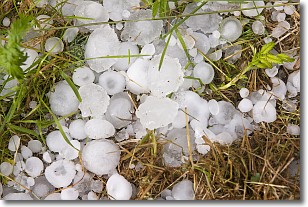
Hail is a form of precipitation which is recognized by large solid balls or
clumps of ice. Hail is created by thunderstorm clouds with strong updrafts of wind.
As the hailstones remain in the updraft, ice is deposited onto them until their
weight becomes heavy enough for them to fall to the earth's surface.
Hail storms can cause significant damage to crops, aircrafts, and man-made structures,
despite the fact that the duration is usually less than ten minutes.
Next Topic: Hole Punch Clouds
Current conditions powered by WeatherAPI.com


