Weather Alert in Nebraska
Red Flag Warning issued March 29 at 12:46AM MDT until March 30 at 9:00PM MDT by NWS Cheyenne WY
AREAS AFFECTED: Pine Ridge/Nebraska National Forest; Box Butte/South Sioux/Niobrara River; Lower North Platte River Basin/Scottsbluff National Monument; Lodgepole Creek/Southern Nebraska Panhandle
DESCRIPTION: ...RED FLAG WARNING IN EFFECT THROUGH MONDAY EVENING FOR MOST OF SOUTHEAST WYOMING... ...RED FLAG WARNING IN EFFECT 10AM SUNDAY THROUGH MONDAY FOR THE WESTERN NEBRASKA PANHANDLE... * AFFECTED AREA...The western Nebraska panhandle, including fire weather zones, 434, 435, 436, 437. * WIND...West winds 10 to 20 mph with gusts to around 30 mph on Sunday. West winds 15 to 25 mph with gusts to around 40 mph on Monday. * HUMIDITY...Minimums of 8 to 15 percent during the afternoon, maximum of 35 to 50 percent in the early morning. * IMPACTS...any fires that develop will likely spread rapidly. Outdoor burning is not recommended. * ADDITIONAL DETAILS...Widely scattered virga showers each evening may produce a few lightning strikes along with gusty and erratic winds accompanied by little to no rainfall. Sunday's activity will be more limited, but more widespread showers are expected Monday afternoon and evening.
INSTRUCTION: A Red Flag Warning means that critical fire weather conditions are either occurring now, or will shortly. A combination of strong winds, low relative humidity, and warm temperatures can contribute to extreme fire behavior.
Want more detail? Get the Complete 7 Day and Night Detailed Forecast!
Current U.S. National Radar--Current
The Current National Weather Radar is shown below with a UTC Time (subtract 5 hours from UTC to get Eastern Time).

National Weather Forecast--Current
The Current National Weather Forecast and National Weather Map are shown below.

National Weather Forecast for Tomorrow
Tomorrow National Weather Forecast and Tomorrow National Weather Map are show below.

North America Water Vapor (Moisture)
This map shows recent moisture content over North America. Bright and colored areas show high moisture (ie, clouds); brown indicates very little moisture present; black indicates no moisture.

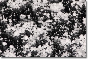
Weather Topic: What is Graupel?
Home - Education - Precipitation - Graupel
 Next Topic: Hail
Graupel is a form of precipitation that is created by atmospheric conditions
which cause supercooled water droplets to contact snow crystals and freeze to
their surface.
Sometimes known as soft hail or snow pellets, graupel is delicate and easily
destroyed by touch. Whereas hail usually falls during severe weather, graupel
doesn't require such conditions to form, and can form in mild precipitation
similar to situations which produce snowfall.
Next Topic: Hail
Weather Topic: What are Hole Punch Clouds?
Home - Education - Cloud Types - Hole Punch Clouds
 Next Topic: Mammatus Clouds
A hole punch cloud is an unusual occurrence when a disk-shaped
hole appears in a cirrostratus, cirrocumulus, or altocumulus cloud.
When part of the cloud forms ice crystals, water droplets in the surrounding area
of the cloud evaporate. The effect of this process produces a large elliptical
gap in the cloud. The hole punch cloud formation is rare, but it is not specific
to any geographic area.
Other names which have been used to describe this phenomena include fallstreak hole,
skypunch, and cloud hole.
Next Topic: Mammatus Clouds
Current conditions powered by WeatherAPI.com


