Weather Alert in New York
Flood Warning issued March 31 at 10:29PM EDT until April 2 at 11:14AM EDT by NWS Buffalo NY
AREAS AFFECTED: Erie, NY; Genesee, NY; Niagara, NY; Wyoming, NY
DESCRIPTION: ...The National Weather Service in Buffalo NY has issued a Flood Warning for the following rivers in New York... Tonawanda Creek At Batavia affecting Erie, Niagara, Genesee and Wyoming Counties. For the Tonawanda Creek...including Batavia...Moderate flooding is forecast. * WHAT...Moderate flooding is forecast. * WHERE...Tonawanda Creek at Batavia. * WHEN...From late tonight to late Thursday morning. * IMPACTS...At 10.0 feet, Moderate flood, flooding along West Main Street and South Main Street in Batavia and along the creek from Batavia to East Pembroke, extending to the Tonawanda Indian Reservation. Flooding will mainly impact roads, with some residential and commerical flooding possible. * ADDITIONAL DETAILS... - At 10:00 PM EDT Tuesday the stage was 4.47 feet. - Bankfull stage is 8.0 feet. - Forecast...The river is expected to rise above flood stage late tonight to a crest of 11.5 feet early Wednesday afternoon. It will then fall below flood stage early Thursday morning. - Flood stage is 9.0 feet. - Flood History...This crest compares to a previous crest of 11.3 feet on 05/05/1976. - http://www.weather.gov/safety/flood
INSTRUCTION: Turn around, don't drown when encountering flooded roads. Most flood deaths occur in vehicles. Caution is urged when walking near riverbanks. Be especially cautious at night when it is harder to recognize the dangers of flooding. Additional information is available at www.weather.gov. The next statement will be issued Wednesday morning by 1030 AM EDT.
Want more detail? Get the Complete 7 Day and Night Detailed Forecast!
Current U.S. National Radar--Current
The Current National Weather Radar is shown below with a UTC Time (subtract 5 hours from UTC to get Eastern Time).

National Weather Forecast--Current
The Current National Weather Forecast and National Weather Map are shown below.

National Weather Forecast for Tomorrow
Tomorrow National Weather Forecast and Tomorrow National Weather Map are show below.

North America Water Vapor (Moisture)
This map shows recent moisture content over North America. Bright and colored areas show high moisture (ie, clouds); brown indicates very little moisture present; black indicates no moisture.

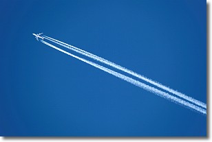
Weather Topic: What are Contrails?
Home - Education - Cloud Types - Contrails
 Next Topic: Cumulonimbus Clouds
A contrail is an artificial cloud, created by the passing of an
aircraft.
Contrails form because water vapor in the exhaust of aircraft engines is suspended
in the air under certain temperatures and humidity conditions. These contrails
are called exhaust contrails.
Another type of contrail can form due to a temporary reduction in air pressure
moving over the plane's surface, causing condensation.
These are called aerodynamic contrails.
When you can see your breath on a cold day, it is also because of condensation.
The reason contrails last longer than the condensation from your breath is
because the water in contrails freezes into ice particles.
Next Topic: Cumulonimbus Clouds
Weather Topic: What are Cumulus Clouds?
Home - Education - Cloud Types - Cumulus Clouds
 Next Topic: Drizzle
Cumulus clouds are fluffy and textured with rounded tops, and
may have flat bottoms. The border of a cumulus cloud
is clearly defined, and can have the appearance of cotton or cauliflower.
Cumulus clouds form at low altitudes (rarely above 2 km) but can grow very tall,
becoming cumulus congestus and possibly the even taller cumulonimbus clouds.
When cumulus clouds become taller, they have a greater chance of producing precipitation.
Next Topic: Drizzle
Current conditions powered by WeatherAPI.com


