Weather Alert in Idaho
Flood Watch issued August 26 at 1:23PM MDT until August 28 at 12:00AM MDT by NWS Pocatello ID
AREAS AFFECTED: Shoshone/Lava Beds; Arco/Mud Lake Desert; Upper Snake River Plain; Lower Snake River Plain; Eastern Magic Valley; Southern Hills/Albion Mountains; Raft River Region; Marsh and Arbon Highlands; Franklin/Eastern Oneida Region; Bear River Range; Bear Lake Valley; Blackfoot Mountains; Caribou Range; Big Hole Mountains; Teton Valley; Centennial Mountains/Island Park; Beaverhead/Lemhi Highlands; Lost River Valleys; Lost River Range; Challis/Pahsimeroi Valleys; Frank Church Wilderness; Sun Valley Region; Big Lost Highlands/Copper Basin; Wood River Foothills
DESCRIPTION: A surge of deep monsoonal moisture will bring a prolonged period of rainfall across eastern Idaho which will result in widespread rainfall totals around 1 inch with locally higher amounts closer to 2 inches possible. This could result in areas of flooding within urban areas along with small creeks and streams. Additionally, there will be some potential for flash flooding, especially over recent burn scars. * WHAT...Flooding caused by excessive rainfall is possible. Flash flooding caused by excessive rainfall is also possible over area burn scars. * WHERE...Portions of central, eastern, south central, and southeast Idaho, including the following areas, in central Idaho, Big Lost Highlands/Copper Basin, Challis/Pahsimeroi Valleys, Frank Church Wilderness, Lost River Range, Lost River Valley, Sun Valley Region and Wood River Foothills. In eastern Idaho, Beaverhead - Lemhi Highlands, Big Hole Mountains, Centennial Mountains - Island Park and Teton Valley. In south central Idaho, Eastern Magic Valley and Shoshone/Lava Beds. In southeast Idaho, Arco/Mud Lake Desert, Bear Lake Valley, Bear River Range, Blackfoot Mountains, Caribou Range, Franklin/Eastern Oneida Region, Lower Snake River Plain, Marsh and Arbon Highlands, Raft River Region, Southern Hills/Albion Mountains and Upper Snake River Plain. * WHEN...Through Wednesday evening. * IMPACTS...Excessive runoff may result in flooding of rivers, creeks, streams, and other low-lying and flood-prone locations. Creeks and streams may rise out of their banks. In addition, flooding may occur in poor drainage and urban areas. * ADDITIONAL DETAILS... - http://www.weather.gov/safety/flood
INSTRUCTION: You should monitor later forecasts and be alert for possible Flood Warnings. Those living in areas prone to flooding should be prepared to take action should flooding develop.
Want more detail? Get the Complete 7 Day and Night Detailed Forecast!
Current U.S. National Radar--Current
The Current National Weather Radar is shown below with a UTC Time (subtract 5 hours from UTC to get Eastern Time).

National Weather Forecast--Current
The Current National Weather Forecast and National Weather Map are shown below.

National Weather Forecast for Tomorrow
Tomorrow National Weather Forecast and Tomorrow National Weather Map are show below.

North America Water Vapor (Moisture)
This map shows recent moisture content over North America. Bright and colored areas show high moisture (ie, clouds); brown indicates very little moisture present; black indicates no moisture.

Weather Topic: What is Fog?
Home - Education - Cloud Types - Fog
 Next Topic: Fractus Clouds
Fog is technically a type of stratus cloud, which lies along the
ground and obscures visibility.
It is usually created when humidity in the air condenses into tiny water droplets.
Because of this, some places are more prone to foggy weather, such as regions
close to a body of water.
Fog is similar to mist; both are the appearance of water droplets suspended in
the air, but fog is the term applied to the condition when visibility is less than 1 km.
Next Topic: Fractus Clouds
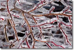
Weather Topic: What is Freezing Rain?
Home - Education - Precipitation - Freezing Rain
 Next Topic: Graupel
Freezing rain is a condition where precipitation which has fallen in the form of
water droplets reaches temperatures which are below freezing and freezes upon
coming into contact
with surface objects. The result of this precipitation is a glaze of ice which
can be damaging to plants and man-made structures. A severe onset of freezing
rain which results in a very thick glaze of ice is known as an ice storm.
Next Topic: Graupel
Current conditions powered by WeatherAPI.com


